| Copyright (c) Queen's Printer, Victoria, British Columbia, Canada | License Disclaimer |
The following electronic version is for informational purposes only.
The printed version remains the official version.
APPENDIX Q
HIGHWAY 17 CORRIDOR
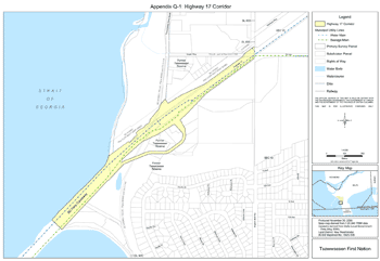
| APPENDIX Q-1 | Map of Highway 17 Corridor |
| APPENDIX Q-2 | List of Public Utility Works within Highway 17 Corridor |
APPENDIX Q-1
Map of Highway 17 Corridor
APPENDIX Q-2
Public Utility Works Within the Highway 17 Corridor
Note: Information will be updated before the Effective Date.
| Interest Holder | Interest | Location | Document Reference Number |
|---|---|---|---|
| British Columbia Hydro and Power Authority | (1) Right-of-Way for electric power transmission and distribution lines; (2) Lease for cable landing facilities |
Along the north side of Highway 17, through Former Tsawwassen Reserve | OCPC 1978-283 (Can)
FNLRS2 1833-32 |
| British Columbia Hydro and Power Authority/Telus Communications Inc. (formerly BC Tel) | (1) Easement for electric power transmission line; (2) Permit for Telephone lines | Crosses Highway 17, through Former Tsawwassen Reserve | FNLRS 7572-248 CLSR Plan M3683 |
| Telus Communications Inc. (formerly BC Tel) | Aerial and underground permit for telephone lines | Intersects with Highway 17 at Tsawwassen Rd. & 16th Ave. | FNLRS 103640 Telus Drawing No. CX-0-1150 |
| Corporation of Delta | Municipal Water and Sewage Mains | Along the south side of Highway 17 to the BC Ferries causeway, through Former Tsawwassen Reserve | Engineering drawings on file with the Corporation of Delta |
| 2 FNLRS - First Nation Land Register System 3 LTO - Land Title Office |
|||