The following electronic version is for informational purposes only.
The printed version remains the official version.
APPENDIX K
YALE FIRST NATION KEY GEOGRAPHICAL FEATURES
| Part 1 | List of Place Names to be Added to the Provincial Geographic Names Database |
| Part 2 | Map of Place Names to be Added to the Provincial Geographic Names Database |
Part 1: List of Place Names to be Added to the Provincial Geographic Names Database
Note: the Parties will update the Appendices before the Effective Date
| Geographical Feature |
Current Name |
Location | Approximate Area (Ha) |
Place Name to be added to the Provincial Geographic Names Database |
| Creek | Unnamed | Flows north into Emory Creek east of proposed power station Appendix B-3, Map 11 |
n/a | Everet's Creek |
| Creek | Unnamed | East side of Fraser River northeast of Indian Reserve 8 Appendix B-2 Part 2, Map 8 |
n/a | Dave's Creek |
| Creek | Suka Creek | Appendix B-2 Part 2, Map 6 | n/a | Squeah Creek |
| Mountain | Unnamed | North of Suka Creek Appendix B-2 Part 2, Map 8 |
n/a | Squeah Mountain |
| Mountain | Unnamed | West of Sacred Rock Appendix B-3, Map 7 |
n/a | Qualark Mountain |
| Mountain | Unnamed | Northwest of Yale Town | n/a | All Hallows Mountain |
| Island | Local unregistered name is Steamboat Island | Adjacent to and north of Indian Reserve 22 Appendix B-3, Map 2 |
1.36 | Steamboat Island |
| Island | Local unregistered name is Saddle Rock | Adjacent to and north of Indian Reserve 22 Appendix B-3, Map 2 |
0.37 | Saddle Rock |
| Four Lakes | Unnamed | Appendix B-3, Map 3 | n/a | Frozen Lakes |
| Historic Yale Indian Reserve | Albert Flat Indian Reserve 5 | Appendix B-2 Part 2, Map 5 | 51.97 | Albert Flat |
| Historic Yale Indian Reserve | Stullawheets Indian Reserve 8 | Appendix B-2 Part 2, Map 8 | 52.11 | Stullawheets |
| Historic Yale Indian Reserve | 4 1/2 Mile Indian Reserve 2 | Appendix B-2 Part 2, Map 1 | 4.36 | 4 1/2 Mile |
| Historic Yale Indian Reserve | Kaykaip Indian Reserve 7 | Appendix B-2 Part 2, Map 7 | 10.47 | Kaykaip |
| Historic Yale Indian Reserve | Squeah Indian Reserve 6 | Appendix B-2 Part 2, Map 6 | 15.63 | Squeah |
| Historic Yale Indian Reserve | Lukseetsissum Indian Reserve 9 | Appendix B-2 Part 2, Map 9 | 52.38 | Lukseetsissum |
| Historic Yale Indian Reserve | Yale Indian Reserve 18 | Appendix B-2 Part 2, Map 3 | 0.56 | Lawrence Hope Rock |
| Historic Yale Indian Reserve | Yale Town Indian Reserve 1 | Appendix B-2 Part 2, Map 4 | 8.29 | Yale Town |
| Historic Yale Indian Reserve | Yale Indian Reserve 19 | Appendix B-2 Part 2, Map 3 | 0.54 | To be removed if no name suggested |
| Historic Yale Indian Reserve | Yale Indian Reserve 20 | Appendix B-2 Part 2, Map 3 | 4.66 | To be removed if no name suggested |
| Historic Yale Indian Reserve | Yale Indian Reserve 21 | Appendix B-2 Part 2, Map 2 | 1.59 | To be removed if no name suggested |
| Historic Yale Indian Reserve | Yale Indian Reserve 22 | Appendix B-2 Part 2, Map 2 | 4.02 | To be removed if no name suggested |
| Historic Yale Indian Reserve | Yale Indian Reserve 23 | Appendix B-2 Part 2, Map 1 | 5.51 | To be removed if no name suggested |
| Historic Yale Indian Reserve | Yale Indian Reserve 24 | Appendix B-2 Part 2, Map 1 | 0.02 | To be removed if no name suggested |
| Historic Yale Indian Reserve | Yale Indian Reserve 25 | Appendix B-2 Part 2, Map 1 | 0.10 | To be removed if no name suggested |
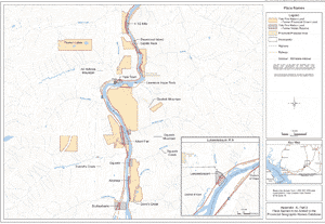
Part 2: Map of Place Names to be Added to the Provincial Geographic Names Database
Appendix K, Part 2
Map of Place Names to be Added to the Provincial Geographic Names Database