| Copyright (c) Queen's Printer, Victoria, British Columbia, Canada | License Disclaimer |
The following electronic version is for informational purposes only.
The printed version remains the official version.
Certified correct as passed Third Reading on the 2nd day of June, 2011
Ian D. Izard, Q.C., Law Clerk
APPENDIX K
YALE FIRST NATION KEY GEOGRAPHICAL FEATURES
| Part 1 | List of Place Names to be Added to the Provincial Geographic Names Database |
| Part 2 | Map of Place Names to be Added to the Provincial Geographic Names Database |
Part 1: List of Place Names to be Added to the Provincial Geographic Names Database
Note: the Parties will update the Appendices before the Effective Date
| Geographical Feature |
Current Name |
Location | Approximate Area (Ha) |
Place Name to be added to the Provincial Geographic Names Database |
| Creek | Unnamed | Flows north into Emory Creek east of proposed power station Appendix B-3, Map 11 |
n/a | Everet's Creek |
| Creek | Unnamed | East side of Fraser River northeast of Indian Reserve 8 Appendix B-2 Part 2, Map 8 |
n/a | Dave's Creek |
| Creek | Suka Creek | Appendix B-2 Part 2, Map 6 | n/a | Squeah Creek |
| Mountain | Unnamed | North of Suka Creek Appendix B-2 Part 2, Map 8 |
n/a | Squeah Mountain |
| Mountain | Unnamed | West of Sacred Rock Appendix B-3, Map 7 |
n/a | Qualark Mountain |
| Mountain | Unnamed | Northwest of Yale Town | n/a | All Hallows Mountain |
| Island | Local unregistered name is Steamboat Island | Adjacent to and north of Indian Reserve 22 Appendix B-3, Map 2 |
1.36 | Steamboat Island |
| Island | Local unregistered name is Saddle Rock | Adjacent to and north of Indian Reserve 22 Appendix B-3, Map 2 |
0.37 | Saddle Rock |
| Four Lakes | Unnamed | Appendix B-3, Map 3 | n/a | Frozen Lakes |
| Historic Yale Indian Reserve | Albert Flat Indian Reserve 5 | Appendix B-2 Part 2, Map 5 | 51.97 | Albert Flat |
| Historic Yale Indian Reserve | Stullawheets Indian Reserve 8 | Appendix B-2 Part 2, Map 8 | 52.11 | Stullawheets |
| Historic Yale Indian Reserve | 4 1/2 Mile Indian Reserve 2 | Appendix B-2 Part 2, Map 1 | 4.36 | 4 1/2 Mile |
| Historic Yale Indian Reserve | Kaykaip Indian Reserve 7 | Appendix B-2 Part 2, Map 7 | 10.47 | Kaykaip |
| Historic Yale Indian Reserve | Squeah Indian Reserve 6 | Appendix B-2 Part 2, Map 6 | 15.63 | Squeah |
| Historic Yale Indian Reserve | Lukseetsissum Indian Reserve 9 | Appendix B-2 Part 2, Map 9 | 52.38 | Lukseetsissum |
| Historic Yale Indian Reserve | Yale Indian Reserve 18 | Appendix B-2 Part 2, Map 3 | 0.56 | Lawrence Hope Rock |
| Historic Yale Indian Reserve | Yale Town Indian Reserve 1 | Appendix B-2 Part 2, Map 4 | 8.29 | Yale Town |
| Historic Yale Indian Reserve | Yale Indian Reserve 19 | Appendix B-2 Part 2, Map 3 | 0.54 | To be removed if no name suggested |
| Historic Yale Indian Reserve | Yale Indian Reserve 20 | Appendix B-2 Part 2, Map 3 | 4.66 | To be removed if no name suggested |
| Historic Yale Indian Reserve | Yale Indian Reserve 21 | Appendix B-2 Part 2, Map 2 | 1.59 | To be removed if no name suggested |
| Historic Yale Indian Reserve | Yale Indian Reserve 22 | Appendix B-2 Part 2, Map 2 | 4.02 | To be removed if no name suggested |
| Historic Yale Indian Reserve | Yale Indian Reserve 23 | Appendix B-2 Part 2, Map 1 | 5.51 | To be removed if no name suggested |
| Historic Yale Indian Reserve | Yale Indian Reserve 24 | Appendix B-2 Part 2, Map 1 | 0.02 | To be removed if no name suggested |
| Historic Yale Indian Reserve | Yale Indian Reserve 25 | Appendix B-2 Part 2, Map 1 | 0.10 | To be removed if no name suggested |
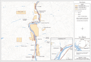
Part 2: Map of Place Names to be Added to the Provincial Geographic Names Database
Appendix K, Part 2
Map of Place Names to be Added to the Provincial Geographic Names Database