| Copyright © King's Printer, Victoria, British Columbia, Canada | Licence Disclaimer |
| B.C. Reg. 224/2013 O.C. 469/2013 | Deposited November 8, 2013 |
Link to Point in Time
Ministry of Lands, Parks and Housing Act
Sole Proponent Fees Regulation
[includes amendments up to B.C. Reg. 292/2016, December 7, 2016]
Definitions
1 In this regulation:
"Digby Island site" means the Crown land described in Schedule E by reference to the sketch attached as Schedule F;
"Grassy Point north site" means the Crown land described in Schedule A by reference to the sketch attached as Schedule B;
"Grassy Point south reduced site" means the Crown land described in Schedule G;
"Grassy Point south site" means the Crown land described in Schedule C by reference to the sketch attached as Schedule D;
"reference date", in respect of a sole proponent agreement, means the date designated in the sole proponent agreement as the reference date for that agreement;
"sole proponent agreement" means an agreement between the government and a person under which the government agrees
(a) not to dispose of specified Crown land for a specified period, and
(b) that the person has exclusive rights for the specified period to pursue a long term tenure in respect of all or part of the specified Crown land.
[am. B.C. Regs. 2/2014, s. 1; 155/2015, s. 1; 292/2016, s. 1.]
Grassy Point north site fees
2 A person with whom the government enters into a sole proponent agreement in respect of Grassy Point north site must pay the following fees to the government:
(a) $12 000 000 on or before the first business day following the date on which the last of the parties to execute and deliver the sole proponent agreement executes and delivers that sole proponent agreement to the other parties;
(b) if, on or before the first anniversary of the reference date of the sole proponent agreement, the person delivers to the government, in accordance with the sole proponent agreement, notice that the person wishes that agreement to continue after that first anniversary, $6 000 000 on or before that anniversary;
(c) if, on or before the second anniversary of the reference date of the sole proponent agreement, the person delivers to the government, in accordance with the sole proponent agreement, notice that the person wishes that agreement to continue after that second anniversary, $6 000 000 on or before that anniversary.
[am. B.C. Reg. 195/2014.]
Grassy Point south site fees
3 A person with whom the government enters into a sole proponent agreement in respect of Grassy Point south site must pay the following fees to the government:
(a) $4 000 000 on or before the first business day following the date on which the last of the parties to execute and deliver the sole proponent agreement executes and delivers that sole proponent agreement to the other party;
(b) if, on or before the first anniversary of the reference date of the sole proponent agreement, the person delivers to the government, in accordance with the sole proponent agreement, notice that the person wishes that agreement to continue after that first anniversary, $6 000 000 on or before that first anniversary;
(c) if, on or before the second anniversary of the reference date of the sole proponent agreement, the person delivers to the government, in accordance with the sole proponent agreement, notice that the person wishes that agreement to continue after that second anniversary, $7 000 000 on or before that second anniversary.
[en. B.C. Reg. 2/2014, s. 2.]
Grassy Point south reduced site fee
3.1 A person with whom the government enters into, on a date that is on or after the date this section comes into force and on or before January 15, 2017, a sole proponent agreement in respect of Grassy Point south reduced site must pay to the government $1 006 525 on or before January 15, 2017 in respect of that agreement.
[en. B.C. Reg. 292/2016, s. 2.]
Digby Island site fees
4 A person with whom the government enters into, on a date that is on or after July 28, 2015 and on or before November 8, 2015, a sole proponent agreement in respect of Digby Island site must pay the following fees to the government:
(a) $6 000 000 on or before November 8, 2015;
(b) if, on or before November 8, 2016, the person delivers to the government, in accordance with the sole proponent agreement, notice that the person wishes that agreement to continue after November 8, 2016, $1 580 259 on or before November 8, 2016.
[en. B.C. Reg. 264/2016.]
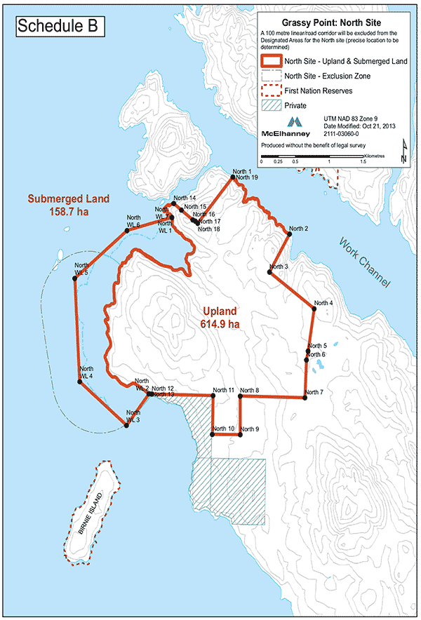
GRASSY POINT NORTH SITE
All those parcels or tracts of Crown land situated in UTM NAD 83 Zone 9 and contained within the following described boundaries:
Grassy Point North Site — Upland
Commencing at North 1 shown on Schedule B at UTM North 6055230 metres East 407800 metres;
thence along the natural boundary of the coast to North 2 shown on Schedule B at UTM North 6054480 metres East 408640 metres;
thence to North 3 shown on Schedule B at UTM North 6053980 metres East 408340 metres;
thence to North 4 shown on Schedule B at UTM North 6053510 metres East 409000 metres;
thence to North 5 shown on Schedule B at UTM North 6052950 metres East 408910 metres;
thence to North 6 shown on Schedule B at UTM North 6052830 metres East 408890 metres;
thence to North 7 shown on Schedule B at UTM North 6052340 metres East 408860 metres;
thence to North 8 shown on Schedule B at UTM North 6052360 metres East 407910 metres;
thence to North 9 shown on Schedule B at UTM North 6051860 metres East 407910 metres;
thence to North 10 shown on Schedule B at UTM North 6051860 metres East 407500 metres;
thence to North 11 shown on Schedule B at UTM North 6052370 metres East 407510 metres;
thence to North 12 shown on Schedule B at UTM North 6052390 metres East 406610 metres;
thence to North 13 shown on Schedule B at UTM North 6052390 metres East 406570 metres;
thence along the natural boundary of the coast to North 14 shown on Schedule B at UTM North 6054880 metres East 406930 metres;
thence to North 15 shown on Schedule B at UTM North 6054790 metres East 407040 metres;
thence to North 16 shown on Schedule B at UTM North 6054670 metres East 407210 metres;
thence to North 17 shown on Schedule B at UTM North 6054650 metres East 407250 metres;
thence to North 18 shown on Schedule B at UTM North 6054620 metres East 407290 metres;
thence to North 19 shown on Schedule B at UTM North 6055230 metres East 407800 metres, being the point of commencement.
The whole upland containing approximately 614.9 ha.
Grassy Point North Site — Submerged Land
All those parcels or tracts of submerged Crown land, together with all that foreshore or land covered by water, situated in UTM NAD 83 Zone 9 and contained within the following described boundaries:
Commencing at North WL 1 shown on Schedule B at UTM North 6054700 metres East 406910 metres;
thence along the natural boundary of the coast to North WL 2 shown on Schedule B at UTM North 6052390 metres East 406570 metres;
thence to North WL 3 shown on Schedule B at UTM North 6051980 metres East 406240 metres;
thence to North WL 4 shown on Schedule B at UTM North 6052550 metres East 405550 metres;
thence to North WL 5 shown on Schedule B at UTM North 6053900 metres East 405470 metres;
thence to North WL 6 shown on Schedule B at UTM North 6054530 metres East 406240 metres;
thence to North WL 7 shown on Schedule B at UTM North 6054700 metres East 406910 metres, being the point of commencement.
The whole submerged area containing approximately 158.7 ha.
[en. B.C. Reg. 2/2014, s. 3.]
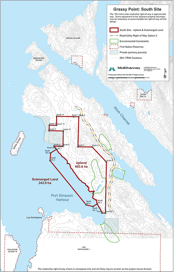
GRASSY POINT SOUTH SITE
All those parcels or tracts of Crown land situated in UTM NAD 83 Zone 9 and contained within the following described boundaries:
Grassy Point South Site — Upland
Commencing at South 1 shown on Schedule D at UTM North 6052340 metres East 408860 metres;
thence to South 2 shown on Schedule D at UTM North 6052340 metres East 409150 metres;
thence to South 3 shown on Schedule D at UTM North 6050650 metres East 409100 metres;
thence to South 4 shown on Schedule D at UTM North 6050640 metres East 409900 metres;
thence to South 5 shown on Schedule D at UTM North 6049780 metres East 410710 metres;
thence to South 6 shown on Schedule D at UTM North 6046920 metres East 410650 metres;
thence to South 7 shown on Schedule D at UTM North 6046930 metres East 410460 metres;
thence along the natural boundary of the coast to South 8 shown on Schedule D at UTM North 6050690 metres East 407760 metres;
thence to South 9 shown on Schedule D at UTM North 6050680 metres East 408270 metres;
thence to South 10 shown on Schedule D at UTM North 6051540 metres East 408280 metres;
thence to South 11 shown on Schedule D at UTM North 6051560 metres East 407480 metres;
thence to South 12 shown on Schedule D at UTM North 6051860 metres East 407500 metres;
thence to South 13 shown on Schedule D at UTM North 6051860 metres East 407910 metres;
thence to South 14 shown on Schedule D at UTM North 6052360 metres East 407910 metres;
thence to South 1 shown on Schedule D at UTM North 6052340 metres East 408860 metres, being the point of commencement.
The whole upland containing approximately 693.6 ha.
Grassy Point South Site — Submerged Land
All those parcels or tracts of submerged Crown land, together with all that foreshore or land covered by water, situated in UTM NAD 83 Zone 9 and contained within the following described boundaries:
Commencing at South WL 1 shown on Schedule D at UTM North 6050510 metres East 407910 metres;
thence along the natural boundary of the coast to South WL 2 shown on Schedule D at UTM North 6047440 metres East 410190 metres;
thence to South WL 3 shown on Schedule D at UTM North 6047290 metres East 409950 metres;
thence to South WL 4 shown on Schedule D at UTM North 6047380 metres East 409580 metres;
thence to South WL 5 shown on Schedule D at UTM North 6049880 metres East 407540 metres;
thence to South WL 6 shown on Schedule D at UTM North 6050300 metres East 407580 metres;
thence to South WL 7 shown on Schedule D at UTM North 6050510 metres East 407910 metres, being the point of commencement.
The whole submerged area containing approximately 243.9 ha.
[en. B.C. Reg. 2/2014, s. 3.]
[en. B.C. Reg. 155/2015, s. 3.]
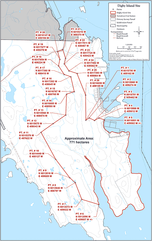
DIGBY ISLAND SITE
All those parcels or tracts of Crown land situated in UTM NAD 83 Zone 9N and contained within the following described boundaries:
Commencing at Point 1 shown on Schedule F at UTM North 6015790 metres East 409162 metres;
thence to Point 2 shown on Schedule F at UTM North 6015868 metres East 409274 metres;
thence to Point 3 shown on Schedule F at UTM North 6015781 metres East 409462 metres;
thence to Point 4 shown on Schedule F at UTM North 6015866 metres East 409612 metres;
thence to the natural boundary of the coast at Point 5 shown on Schedule F at UTM North 6015801 metres East 409802 metres +/-;
thence along the natural boundary of the coast to Point 6 on Schedule F at UTM North 6012896 metres East 409607 metres +/-;
thence to Point 7 shown on Schedule F at UTM North 6013073 metres East 409022 metres;
thence to Point 8 shown on Schedule F at UTM North 6013648 metres East 408797 metres;
thence to Point 9 shown on Schedule F at UTM North 6013816 metres East 408609 metres;
thence to Point 10 shown on Schedule F at UTM North 6014449 metres East 408127 metres;
thence to Point 11 shown on Schedule F at UTM North 6015376 metres East 407622 metres;
thence to Point 12 shown on Schedule F at UTM North 6015675 metres East 408043 metres;
thence to Point 13 shown on Schedule F at UTM North 6015968 metres East 408474 metres;
thence to Point 14 shown on Schedule F at UTM North 6016685 metres East 408500 metres;
thence to Point 15 shown on Schedule F at UTM North 6016767 metres East 408765 metres;
thence to Point 16 shown on Schedule F at UTM North 6017282 metres East 408645 metres;
thence to Point 17 shown on Schedule F at UTM North 6017360 metres East 408418 metres;
thence to Point 18 shown on Schedule F at UTM North 6017654 metres East 408224 metres;
thence to Point 19 shown on Schedule F at UTM North 6017877 metres East 408270 metres;
thence to Point 20 shown on Schedule F at UTM North 6018147 metres East 408194 metres;
thence to Point 21 shown on Schedule F at UTM North 6018216 metres East 408370 metres;
thence to Point 22 shown on Schedule F at UTM North 6017911 metres East 408467 metres;
thence to Point 23 shown on Schedule F at UTM North 6017724 metres East 408423 metres;
thence to Point 24 shown on Schedule F at UTM North 6017482 metres East 408582 metres;
thence to Point 25 shown on Schedule F at UTM North 6017393 metres East 408864 metres;
thence to Point 26 shown on Schedule F at UTM North 6016656 metres East 409155 metres;
thence to Point 1 shown on Schedule F at UTM North 6015790 metres East 409162 metres, being the point of commencement.
The whole containing approximately 771 ha.
[en. B.C. Reg. 155/2015, s. 3.]
[en. B.C. Reg. 292/2016, s. 3.]
GRASSY POINT SOUTH REDUCED SITE
All those parcels or tracts of Crown land situated in UTM NAD 83 Zone 9N and contained within the following described boundaries:
Commencing at UTM North 6046901 metres East 410633 metres;
thence clockwise to the natural boundary of Stumaun Bay at UTM North 6046913 metres East 410467 metres +/-;
thence following the natural boundary of Stumaun Bay to UTM North 6048175 metres East 409729 metres +/-;
thence to UTM North 6047847 metres East 409314 metres;
thence to UTM North 6049312 metres East 408144 metres;
thence to UTM North 6049509 metres East 408379 metres;
thence to UTM North 6050405 metres East 407681 metres;
thence to the natural boundary of Rushbrook Passage at UTM North 6050531 metres East 407883 metres +/-;
thence following the natural boundary of Rushbrook Passage to UTM North 6050732 metres East 407755 metres +/-;
thence to UTM North 6050718 metres East 408025 metres;
thence to UTM North 6050283 metres East 408365 metres;
thence to UTM North 6049949 metres East 408797 metres;
thence to UTM North 6050131 metres East 409041 metres;
thence to UTM North 6049042 metres East 409890 metres;
thence to UTM North 6048284 metres East 410141 metres;
thence to UTM North 6047365 metres East 410645 metres;
thence to UTM North 6046901 metres East 410633 metres, being the point of commencement.
The whole containing approximately 333.2 ha.
[Provisions relevant to the enactment of this regulation: Ministry of Lands, Parks and Housing Act, R.S.B.C. 1996, c. 307, section 11]
Copyright © King's Printer, Victoria, British Columbia, Canada