Regulation BEFORE repealed by BC Reg 529/2004, effective January 12, 2005.
| B.C. Reg. 297/88 O.C. 1433/88 | Deposited August 8, 1988 effective August 15, 1988 |
Mineral Tenure Act
Mineral Tenure Act Regulation
Interpretation
1 (1) In this regulation:
"Act" means the Mineral Tenure Act;
"archeological impact assessment" means any heritage inspection or heritage investigation that
(a) the Chief Inspector of Mines requires a recorded holder to undertake as a condition of a permit issued under the Mines Act,
(b) is carried out by an individual who holds a permit under section 14 of the Heritage Conservation Act, and
(c) is described in an application submitted by the recorded holder under section 10 of the Mines Act,
"boundary" means the perimeter of a mineral title;
"cardinal direction" means, for the purpose of locating a 1 post claim, the direction that lies upon a 1 post claim grid line;
"Chief Inspector of Mines" means a "chief inspector" as defined in the Mines Act;
"corner post" means an identification post firmly affixed to the ground, placed at any of the corners of a 4 post claim other than the corner from which the location of the claim is determined;
"Crown granted 2 post claim" means a mineral title issued under a former Act to some or all minerals that were subsequently Crown granted and includes those 2 post claims formerly Crown granted in which all minerals have since vested or have been reserved to the Crown;
"direction" means a bearing measured between 0° and 360° , where 0° is the bearing of true north;
"final post" means a legal post, placed at the end of the location line where the location of a 2 post claim or placer claim is completed;
"fractional mineral claim" means a mineral title located pursuant to this regulation;
"gold commissioner" means a gold commissioner appointed under section 4 of the Act and includes the chief gold commissioner appointed under that section;
"identification post" means a post, other than a legal post, firmly affixed to the ground in accordance with this regulation, that consists of
(a) a piece of sound timber, standing upright, not less than one metre above the ground, squared and faced on 4 sides for at least 25 cm from the top, so that the width of the adjacent cut faces measure no less than 38 mm and 89 mm,
(b) a stump or tree of sound wood standing upright, cut off not less than one metre above the ground, squared and faced on 4 sides for at least 25 cm from the top, so that the width of the adjacent cut faces measure no less than 38 mm and 89 mm, or
(c) a cairn of stones not less than 50 cm in height above the ground;
"initial post" means a legal post, placed at the point from which the location of a 2 post claim or placer claim is commenced;
"legal post" means a post, firmly affixed to the ground, used to locate a mineral title, that establishes the point from which its location is determined, marked in accordance with this regulation, and consists of
(a) a piece of sound timber, standing upright, not less than one metre above the ground, squared and faced on 4 sides for at least 25 cm from the top, so that the width of the cut faces measure no less than 89 mm,
(b) a stump or tree of sound wood, standing upright, cut off not less than one metre above the ground, squared and faced on 4 sides for at least 25 cm from the top, so that the width of the cut faces measure no less than 89 mm, or
(c) a rock cairn not less than one metre in height above the ground;
"location line" means the straight line between the initial post and final post;
"locator" means the free miner who locates a title under this regulation;
"metal tag" means a serially numbered tag provided by the minister;
"mineral claim" includes a 4 post claim, 2 post claim, 1 post claim and fractional mineral claim;
"unit" means
(a) a square enclosing an area up to 25 ha in a 4 post claim, 2 post claim or 1 post claim located in accordance with this regulation, or
(b) a placer claim;
"witness post" means a legal post used to indicate the true position of a legal corner post or final post;
"width of location" means the width of a 2 post claim or placer claim;
"1 post claim" means a mineral title within a 1 post claim grid acquired in accordance with this regulation;
"1 post claim grid" means a square or rectangular shape placed on a map by the chief gold commissioner and used to determine the boundary of a 1 post claim;
"2 post claim" means a mineral title located in accordance with this regulation;
"4 post claim" means a mineral title located in accordance with this regulation.
(2) Where a horizontal measurement is required to be made under this regulation the measurement shall be taken irrespective of any irregularities on the surface of the ground.
(3) Where a metal tag is required by this regulation to be affixed to a post, it shall be securely affixed with 4 broad headed nails.
[am. B.C. Regs. 63/89, s. 1; 454/95, s. 1; 107/2001, s. 1.]
Exploration and development activity
1.1 The following are prescribed activities for the purposes of the definition of "exploration and development" in section 1 of the Act:
(a) a Global Positioning System survey;
(b) a one-time bulk sample;
(c) an archaeological impact assessment.
[en. B.C. Reg. 157/99, Sch. 1, s. 1; am. B.C. Reg. 107/2001, s. 2.]
Minimum standard of knowledge for free miner certificate
1.2 (1) The minimum standard of knowledge for the purposes of section 8 (2) (a) (ii) of the Act is an adequate knowledge of
(a) the rights and responsibilities of a free miner under the Act and the regulations including, without limitation, knowledge of the following:
(i) the process for acquiring, locating, recording and maintaining a claim;
(ii) the rights acquired with the location of a claim;
(iii) the lands on which a free miner may not enter;
(iv) the notices that must be given before beginning work on a claim;
(v) the limits on production from a claim,
(b) the rights and responsibilities of a free miner under other enactments, and
(c) integrated resource management principles in British Columbia and their application to mineral exploration.
[en. B.C. Reg. 454/95, s. 2.]
Size and shape of a 4 post claim
2 Subject to section 15:
(a) every 4 post claim shall have the shape of either a square or a rectangle;
(b) the area covered by a 4 post claim
(i) shall not be less than 25 ha and shall not exceed 500 ha, and
(ii) shall be divisible into squares of 25 ha, (see figure 1)
 |
| Figure 1. Example shows a 6 unit claim. Each unit contains 25 ha and measures 500 m X 500 m. Locator has claimed 2 unit lengths north and 3 unit lengths west. |
(c) determination of the easterly or westerly boundary extending from the legal corner post of a 4 post claim shall be made by establishing the astronomic meridian passing through the legal corner post, which meridian shall form either the easterly or westerly boundary of the 4 post claim,
(d) the northerly and southerly boundaries shall be at right angles to the meridian,
(e) the remaining easterly or westerly boundary shall be parallel to the meridian referred to in paragraph (c) (see figure 2), and
(f) the boundaries shall measure 500 m or full multiples of 500 m up to but not exceeding 4 000 m in any one direction.
 |
| Figure 2. Claim boundaries of a 4 post mineral claim relative to true north. |
Locating a 4 post claim
3 (1) On request, a gold commissioner shall furnish a person with a set of 4 metal tags, one tag embossed "LEGAL CORNER POST" and the other 3 embossed "CORNER POST". (see figure 3)
 |
| Figure 3. Example of metal tags for the legal corner post and corner posts for a 4 post mineral claim. |
(2) Every 4 post claim shall be marked on the ground by the locator by
(a) placing a legal corner post at the corner of the claim,
(b) affixing to the squared surface of a side of the legal corner post which faces in one of the directions of the boundary line extending from the legal corner post a serially numbered metal tag, embossed "LEGAL CORNER POST" and legibly and permanently impressing on it the following information:
(i) the name given to the claim;
(ii) the name of the locator;
(iii) the free miner certificate number of the locator;
(iv) the name of the person for whom the locator is acting as agent, if any;
(v) the free miner certificate number of the person for whom the locator is acting as agent;
(vi) the date and time of day of the commencement of the location;
(vii) the date and time of day of the completion of the location;
(viii) the number of unit lengths claimed, North and East or North and West or South and East or South and West;
(c) marking the boundary of the mineral claim as near as possible to the true position of the boundary by
(i) placing identification posts and corner posts along the boundaries at 500 m intervals except where, because of the presence of water or glacial ice or because of prevailing topographical conditions, it is not feasible to place the identification posts or corner posts, and
(ii) blazing standing trees on 2 sides approximately facing an identification post, corner post or legal corner post and by cutting underbrush or marking the line between the posts in as permanent a manner as conditions permit, so that, from each mark on the line, the next mark on the foresite is visible, and similarly, the last mark on the backsite is also visible,
(d) legibly and permanently marking on the squared surface on the side of every identification post that faces either direction of the boundary line the following information:
(i) the name given to the claim;
(ii) the post number;
(iii) the metal tag number;
(iv) the date the identification post was placed, and
(e) affixing to the squared surface of the side of the corner post that faces in one of the directions of the boundary line of the mineral claim extending from the corner post a metal tag embossed "CORNER POST", and legibly and permanently impressing on it the following information:
(i) the name given to the claim;
(ii) the post number;
(iii) the name of the locator;
(iv) the free miner certificate number of the locator;
(v) the name of the person for whom the locator is acting as an agent, if any;
(vi) the free miner certificate number of the person for whom the locator is acting as an agent;
(vii) the date the corner post was placed.
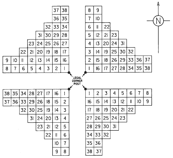
(3) The identification posts and corner posts placed along the boundaries shall be numbered to indicate their positions relative to the position of the legal corner post by the number of unit lengths and cardinal direction each post is from the legal corner post. (see figure 4)
 |
| Figure 4. Example of numbering of corner posts and identification posts of a 4 post mineral claim. |
(4) Where the identification posts or corner posts cannot be placed in accordance with subsection (2) (c) (i), the legal corner post shall be legibly and permanently marked with the numbers of the identification posts or corner posts not placed.
(5) Where a cairn of stones is used as a legal corner post or corner post, the metal tag, with the information impressed on it pursuant to subsection (2) (b) and (e), shall be placed securely within the cairn of stones.
(6) Where a cairn of stones is used as an identification post, the information required under subsection (2) (d) shall be legibly and permanently marked on a metal tag or waterproof material, as the case may be, and placed securely within the cairn of stones.
(7) The location of a mineral claim shall not be considered complete until the legal corner post has been placed or witnessed and the claim boundary has been marked in accordance with this regulation.
(8) Where contiguous 2 post claims, 4 post claims, fractional mineral claims or reverted Crown granted 2 post claims are abandoned pursuant to section 37 of the Act and the ground is being relocated with 4 post claims pursuant to section 38 (1), (2), (3) and (4) of the Act,
(a) the requirements of subsection (2) (c), (d) and (e) of this regulation may be omitted with respect to the common boundaries of the relocating 4 post claims,
(b) the outside perimeter of the total ground covered by the relocating claims shall be marked as required by this regulation, and
(c) the legal corner posts of the relocating 4 post claims must be positioned on the outside perimeter of the total ground covered by the relocating claims.
[am. B.C. Reg. 454/95, s. 3.]
Marking legal corner post by witness post
6 If, because of the presence of water or glacial ice or because of prevailing topographical conditions, it is not feasible for a locator of a mineral claim to place the legal corner post, identification posts and corner posts in accordance with section 3 (2), the legal corner post shall be marked by
(a) placing a witness post as close as possible to, but in any case within 5 000 m of, where the legal corner post should have been placed,
(b) legibly and permanently marking that side of the witness post that faces in the direction of the legal corner post being witnessed,
(i) the words "WITNESS POST", and
(ii) the direction and distance to the true position of the legal corner post,
(c) affixing to the squared surface of that side of the witness post which faces in the direction of the legal corner post being witnessed a metal tag embossed "LEGAL CORNER POST" and legibly and permanently impressing on it the information required under section 3 (2) (b),
(d) placing an identification post in a conspicuous place no closer than 100 m from the witnessed legal corner post,
(e) legibly and permanently marking that side of the identification post that faces in the direction of the witness post with the following information:
(i) the words "IDENTIFICATION POST";
(ii) the name given to the claim;
(iii) the metal tag number;
(iv) the direction and distance to the witness post;
(v) the date of the location, and
(f) marking the line between the identification post and witness post in accordance with section 3 (2) (c) (ii). (see figure 6)
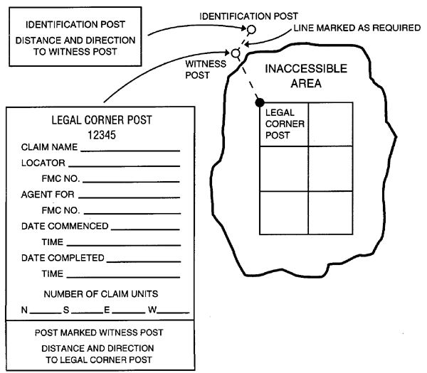 |
| Figure 6. Example of a witness post staking of a 4 post mineral claim. |
[am. B.C. Reg. 454/95. s. 5.]
Unit identification
7 Units shall be numbered in the sequence set out in the following figure:
 |
| Figure 7. Unit numbering for 4 post mineral claims. |
Reduction of 4 post claim
8 (1) A 4 post claim may be reduced in size, on application by a recorded holder filed with a gold commissioner, on the following conditions:
(a) subject to subsection (2), a reduced claim shall have the shape of either a square or rectangle;
(b) the legal corner post shall be included in the boundary of the reduced claim;
(c) units to be dropped must be indicated by using the numbering system under section 7;
(d) only one application for reduction may be made during each anniversary year of a 4 post claim.
(2) Subsection (1) (a) does not apply where partial overstaking occurs in accordance with section 15.
(3) In subsection (1) (d) "anniversary year" means the 12 month period from the date of record of the claim to the anniversary date and thereafter each 12 month period from one anniversary date to the next.
Disposition of Crown granted 2 post claim
8.1 (1) Where a Crown granted 2 post claim has reverted, escheated or been surrendered to the Crown, or is otherwise acquired by the Crown, the chief gold commissioner may
(a) dispose of it as a 2 post claim, on terms he considers appropriate, by public auction or public tender not earlier than 4 weeks after the intended disposal is advertised in the Gazette,
(b) make the mineral land that was subject to the Crown granted 2 post claim available for the location and recording of a claim by advertising in the Gazette the date it becomes available, or
(c) dispose of it as a 2 post claim on the terms and conditions the chief gold commissioner considers appropriate by advertising in the Gazette the date it becomes available.
(2) No free miner shall locate or record a claim on land that was subject to a Crown granted 2 post claim that has reverted, escheated or been surrendered to the Crown or otherwise been acquired by the Crown until
(a) the Crown granted 2 post claim has been disposed of under subsection (1) (a) or (c), or
(b) the mineral land has become available for location and recording under subsection (1) (b).
(3) A free miner who has acquired a claim under subsection (1) (a) or (c) may, without locating the claim, apply to the gold commissioner to have it recorded under section 23 and the gold commissioner shall record it as a 2 post claim.
[en. B.C. Reg. 30/90; am. B.C. Reg. 157/99, Sch. 1, s. 2.]
Size and shape of a 2 post claim
9 Subject to section 15,
(a) a 2 post claim shall not exceed 500 m by 500 m,
(b) the boundaries of a 2 post claim shall be measured and the area of the 2 post claim shall be determined by establishing its lines running from the No. 1 post and from and through the No. 2 post at right angles to the location line, and by establishing its side lines parallel to the location line (see figure 8),
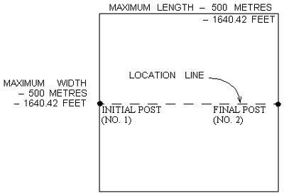 |
| Figure 8. Maximum size of a 2 post mineral claim. |
(c) if during a survey of a 2 post claim, the British Columbia land surveyor conducting the survey determines that the distance between the No. 1 and No. 2 post exceeds
(i) 457.2 m for a 2 post claim located before this regulation comes into force, or
(ii) 500 m for a 2 post claim located after this regulation comes into force
the surveyor shall establish the effective position of the No. 2 post at a point on the location line a distance specified in paragraph (i) or (ii), as the case may be, from the No. 1 post, but shall not disturb the actual position of the No. 2 post, or
(d) if during the conduct of a survey, it is found that
(i) either of the posts of a 2 post claim is on a previously located claim or on a boundary of a previously located claim,
(ii) the boundary line of a previously located claim is not at right angles to the location line of the claim being surveyed, and
(iii) the area of the claim being surveyed, including a fraction created, does not exceed
(A) 20.90 ha for a 2 post claim located before this regulation comes into force, or
(B) 25 ha for a 2 post claim located after this regulation comes into force
the British Columbia land surveyor conducting the survey shall include the fraction created along the boundary touched or crossed by the location line within the claim being surveyed.
Locating 2 post claims
10 (1) On request, a gold commissioner shall furnish a person with a set of 2 metal tags, one embossed "INITIAL POST (No. 1)" and the other embossed "FINAL POST (No. 2)". (see figure 9)
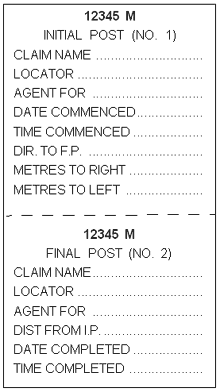 |
| Figure 9. Example of tags used to locate a 2 post mineral claim. |
(2) Every 2 post claim shall be marked on the ground by the locator by
(a) placing an initial post called "No. 1" and final post called "No. 2" from which the location of the 2 post claim is determined,
(b) affixing to the squared surface of that side of the No. 1 post which faces in the direction of the No. 2 post, that portion of the metal tag embossed "INITIAL POST (No. 1)" and legibly and permanently impressing on it the following information:
(i) the name given to the claim;
(ii) the name of the locator;
(iii) the name of the person for whom the locator is acting as an agent, if any;
(iv) the date and time of day of commencement of the location;
(v) the direction to the No. 2 post;
(vi) Repealed. [B.C. Reg. 454/95, s. 6.]
(vii) a statement of the distance lying to the right or left, or to both, of the location line determined when facing the direction of the No. 2 post,
(c) marking the location line between the No. 1 and No. 2 posts by blazing standing trees on 2 sides approximately facing the No. 1 and No. 2 posts and by cutting underbrush or marking the line between the posts in as permanent a manner as conditions permit, so that, from each mark on the line, the next mark on the foresite is visible and, similarly, the last mark on the backsite is also visible, and
(d) affixing to the squared surface of that side of the No. 2 post, which faces in the direction of the No. 1 post, that portion of the metal tag embossed "FINAL POST (No. 2)" and legibly and permanently impressing on it the following information:
(i) the name given to the claim;
(ii) the name of the locator;
(iii) the name of the person for whom the locator is acting as an agent, if any;
(iv) the distance from the No. 1 post;
(v) the date and time of day of completion of the location. (see figure 10)
(3) Where a cairn of stones is used for the No. 1 post or No. 2 post, the metal tag, with the information impressed on it, as required under subsection (1) (b) and (d), shall be placed securely within the cairn of stones.
(4) The location of a 2 post claim shall be considered completed only after the No. 1 post has been placed and the No. 2 post has been placed or witnessed and the location line has been marked in accordance with this regulation.
(5) For purposes of the Act, the legal corner post of a 2 post claim is the No. 1 post.
(6) One set of metal tags shall be used for each 2 post claim.
 |
| Figure 10. Modes of staking a 2 post mineral claim. |
[am. B.C. Regs. 84/89; 454/95, s. 6.]
Witness post 2 post claim
11 (1) Where, because of the presence of water or glacial ice or because of prevailing topographic conditions, it is not feasible for a locator of a 2 post claim to place the No. 2 post in accordance with section 10, the No. 2 post of the 2 post claim shall be marked by
(a) placing a witness post for the No. 2 post on the location line as close as possible to where the No. 2 post should have been placed,
(b) legibly and permanently marking the side of the witness post that faces in the direction of the post being witnessed, with the following information:
(i) the words "No. 2 WITNESS POST";
(ii) the direction and distance to the true position of the No. 2 post, and
(c) securely affixing to the squared surface of that side of the witness post that faces in the direction of the No. 2 post being witnessed a metal tag embossed "Final Post No. 2" and legibly and permanently impressing on it the information required under section 10 (2) (d). (see figure 11)
 |
| Figure 11. Example of a witness post staking of a 2 post mineral claim. |
(2) The distance impressed on the metal tag referred to in subsection (1) (c) must be the full claimed distance between the initial post and the intended true position of the final post.
[am. B.C. Reg. 454/95, s. 7.]
Size and shape of a 1 post claim
11.1 Subject to section 15,
(a) every 1 post claim shall have the shape of either a square or a rectangle,
(b) the area covered by a 1 post claim
(i) shall not be less than 400 ha and shall not exceed 600 ha, and
(ii) shall be divisible into units of 25 ha, (see figure 11.1)
(c) boundaries shall measure 2 000 m but shall not exceed 3 000 m in any direction, and
(d) boundaries shall be determined from a map, published by the chief gold commissioner, which establishes
(i) the position of the legal corner post in the southwest corner of the claim, and
(ii) the Universal Transverse Mercator projection grid lines which form the boundary of the claim.
 |
| Figure 11.1. Size and shape of a 1 post claim. |
[en. B.C. Reg. 63/89, s. 2.]
Locating a 1 post claim
11.2 (1) On request, a gold commissioner shall furnish a person with one metal tag embossed "LEGAL CORNER POST". (see figure 3)
(2) Every 1 post claim shall be marked on the ground by the locator by
(a) placing a legal corner post as close as possible to the southwest corner of the claim which is marked on the map, and
(b) securely affixing to the squared surface of a side of the legal corner post which faces in a northerly or easterly direction a serially numbered metal tag embossed "LEGAL CORNER POST" and legibly and permanently impressing on it the following information:
(i) the alphanumeric name given to the claim as shown on the map;
(ii) where the claim is in a recreation area, the letters "(RAC)" after the alphanumeric name;
(iii) the name of the locator;
(iv) the free miner certificate number of the locator;
(v) the name of the person for whom the locator is acting as agent, if any;
(vi) the free miner certificate number of the person for whom the locator is acting as agent;
(vii) the date and time of day of the completion of the location.
(3) Where, because of the presence of water or glacial ice or because of prevailing topographic conditions or other inhibiting conditions, it is not feasible for the locator of a 1 post claim to place the legal corner post in accordance with subsection (2) (a), the locator shall
(a) place the legal corner post as close as possible to the southwest corner along the south or west boundaries, and
(b) legibly and permanently impress on the metal tag the following information:
(i) the words "Offset LCP";
(ii) the distance and cardinal direction along the boundary to the true position of the legal corner post;
(iii) the information required under subsection (2) (b) (i) to (vii).
(4) Where a 1 post claim includes both land designated as recreation area under section 23 of the Act and mineral lands, any time limitation that applies to the recreation area does not apply to the mineral lands.
(5) The chief gold commissioner may consolidate adjoining portions of 1 post claims on the map, subject to the size limitations under section 11.1 for a 1 post claim, and the consolidated 1 post claim shall form one claim on the map.
[en. B.C. Reg. 63/89, s. 2.]
Witness post 1 post claim
11.3 Where, because of the presence of water or glacial ice or because of prevailing topographic conditions, it is not feasible for a locator of a 1 post claim to place the legal corner post in accordance with section 11.2 (3), the legal corner post shall be marked by
(a) placing a witness post for the legal corner post as close as possible to, but in any case within 6 000 m of, and at the southwest corner of, any 1 post claim situated in a cardinal direction from where the legal corner post should have been placed, and
(b) legibly and permanently impressing on the metal tag the following information:
(i) the words "WITNESS LCP";
(ii) the distance and cardinal direction to the true position of the legal corner post;
(iii) the information required under section 11.2 (2) (b) (i) to (vii). (see figure 11.2)
 |
| Figure 11.2. Witnessed 1 post claim. |
[en. B.C. Reg. 63/89, s. 2.]
Identification line
11.4 (1) Where, because of the presence of thick vegetation or because of prevailing topographic conditions, the legal corner post, offset legal corner post or witness legal corner post is placed on the ground in such a manner as to be obscured from view, the locator shall place an identification line from the post to a more visible or prominent point.
(2) The identification line shall consist of a marking which, when placed, does not destroy or damage the vegetation.
[en. B.C. Reg. 63/89, s. 2.]
Mineral title within 1 post claim grid
11.5 No mineral title other than a 1 post claim and a mining lease may be acquired within a 1 post claim grid.
[en. B.C. Reg. 63/89, s. 2.]
Expropriation of recreation area
11.6 Where a 1 post claim includes land outside of a recreation area designated under section 23 of the Act, the powers of expropriation of the recreation area conferred by section 11 of the Park Act are not exercisable in relation to the land outside the recreation area.
[en. B.C. Reg. 63/89, s. 2.]
Complaint as to location of 1 post claim
11.7 Where a complaint is made under section 40 (1) (a) of the Act with respect to the location of a 1 post claim, the chief gold commissioner may require an investigation and report, and the report shall have particular reference to the
(a) priority of location,
(b) accuracy of the positioning of the legal corner post in relation to the southwest corner of the 1 post claim,
(c) appropriateness of the utilization of the offset legal corner post or witness legal corner post, and
(d) completeness of information on the metal tag.
[en. B.C. Reg. 63/89, s. 2.]
Acquiring a 1 post claim by application
11.8 (1) Where, on a map issued by the chief gold commissioner, a 1 post claim is designated as available without location of the legal corner post, a free miner may apply for a record of the 1 post claim.
(2) Application under this section for a record of a 1 post claim may be made on or after April 17, 1989, commencing at 10 a.m. Pacific Standard time, by a free miner appearing in person at
(a) the office of a gold commissioner designated by the chief gold commissioner, or
(b) the office of the Vancouver Mining Division.
(3) Where 2 or more applicants wish to apply simultaneously or applications are received simultaneously under this section for a 1 post claim, disposition shall be made by draw at 2 p.m. on the day of disposition.
(4) The draw under subsection (3) shall be conducted by the gold commissioner in Vancouver as follows:
(a) ballots shall be prepared naming each applicant and the claim being applied for;
(b) the ballots shall be folded, placed in a receptacle and thoroughly mixed by an independent person;
(c) the independent person shall make the draw and announce the successful applicant;
(d) the gold commissioner shall notify the successful applicant.
[en. B.C. Reg. 63/89, s. 2.]
Size and shape of a placer claim
12 (1) A placer claim shall not exceed a length of location of 1 000 m or a width of location of 500 m.
(2) The boundaries of a placer title shall be measured and the area of the placer title shall be determined by establishing its lines running from or through the No. 1 post and from or through the No. 2 post, at right angles to the location line, and by establishing its side lines parallel to the location line. (see figure 12)
 |
| Figure 12. Maximum size of a placer claim. |
(3) If during the conduct of a survey of a placer title, the British Columbia land surveyor conducting the survey determines that the distance between the No. 1 and No. 2 post exceeds
(a) 2 640 feet for a placer title issued prior to June 1, 1975, or
(b) 1 000 m for a placer title issued on or after June 1, 1975,
the surveyor shall establish the effective position of the No. 2 post at a point on the location line a distance specified in section 3 (a) or (b), as the case may be, from the No. 1 post but shall not disturb the actual position of the No. 2 post.
(4) Where during the conduct of a survey, it is found that
(a) either of the posts of a placer title is on a previously located placer title or on a boundary of a previously located placer title,
(b) the boundary line of a previously located placer title is not at right angles to the location line of the placer title being surveyed, and
(c) the area of the placer title being surveyed, including a fraction created, does not exceed
(i) 32.37 ha for a placer title located prior to June 1, 1975, or
(ii) 50 ha for a placer title located on or after June 1, 1975,
the British Columbia land surveyor conducting the survey shall include the fraction created along the boundary touched or crossed by the location line within the placer title being surveyed.
Locating placer claims
13 (1) On request, a gold commissioner shall furnish a person with a set of 2 metal tags, one embossed "PLACER INITIAL POST (No. 1)" and the other embossed "PLACER FINAL POST (No. 2)". (see figure 13)
 |
| Figure 13. Example of tags used to locate a placer claim. |
(2) Every placer claim shall be marked on the ground by the locator by
(a) placing an "PLACER INITIAL POST (No. 1)" called "No. 1" and "PLACER FINAL POST (No. 2)" called "No. 2" from which the location of the placer claim is determined,
(b) securely affixing to the squared surface of that side of the No. 1 post which faces in the direction of the No. 2 post, that portion of a the metal tag embossed "PLACER INITIAL POST (No. 1)" and legibly and permanently impressing on it the following information:
(i) the name given to the placer claim;
(ii) the name of the locator;
(iii) the name of the person for whom the locator is acting as an agent, if any;
(iv) the date and time of day of commencement of the location;
(v) the direction to the No. 2 post;
(vi) a statement of the number of metres or lying to the right or to the left, or both, of the location line determined when facing the direction of the No. 2 post,
(c) marking the location line between the No. 1 and No. 2 posts by blazing standing trees on 2 sides approximately facing the No. 1 and No. 2 posts and by cutting underbrush or marking the line between the posts in as permanent a manner as conditions permit, so that, from each mark on the line, the next mark on the foresite is visible and, similarly, the last mark on the backsite is also visible, and
(d) securely affixing to the squared surface of that side of the No. 2 post, which faces in the direction of the No. 1 post, that portion of the metal tag embossed "PLACER FINAL POST (No. 2)" and legibly and permanently impressing on it the following information:
(i) the name given to the placer claim;
(ii) the name of the locator;
(iii) the name of the person for whom the locator is acting as an agent, if any
(iv) the distance from the No. 1 post;
(v) the date and time of day of completion of the location. (see figure 14)
(3) Where a cairn of stones is used for the No. 1 post or No. 2 post, the metal tag, with the information impressed on it in accordance with subsection (2) (b) and (d), shall be placed securely within the cairn of stones.
(4) The location of a placer claim shall be considered complete only after the No. 1 post has been placed, the No. 2 post has been placed or witnessed and the location line has been marked in accordance with this regulation.
(5) For purposes of the Act, the legal corner post of a placer claim is the No. 1 post.
(6) One set of metal tags shall be used for each placer claim.
 |
| Figure 14. Modes of staking a placer claim. |
[am. B.C. Regs. 419/88; 454/95, s. 8.]
Witness post placer claim
14 (1) Where, because of the presence of water or glacial ice or because of prevailing topographic conditions, it is not feasible for a locator of a placer claim to place the No. 2 post in accordance with section 13, the No. 2 post of the placer claim shall be marked by
(a) placing a witness post for the No. 2 post on the location line as close as possible to where the No. 2 posts should have been placed,
(b) legibly and permanently marking the side of the witness post that faces in the direction of the post being witnessed, with the following information:
(i) the words "No. 2 WITNESS POST";
(ii) the direction and distance to the true position of the No. 2 post, and
(c) affixing to the squared surface of the side of the witness post that faces in the direction of the No. 2 post being witnessed the metal tag embossed "PLACER FINAL POST (No. 2)" and legibly and permanently impressing on it the information required under section 13 (1) (d). (see figure 15)
 |
| Figure 15. Example of a witness post staking of a placer claim. |
(2) The distance impressed on the metal tag referred to in subsection (1) (c) must be the full claimed distance between the initial post and the intended true position of the final post.
[am. B.C. Reg. 454/95, s. 9.]
Plan of survey
14.1 (1) In the notice of intention to apply for a placer lease, the applicant shall submit a plan of a survey of the area intended for lease prepared by a British Columbia land surveyor, which plan has been approved by the Surveyor General, or a plan which shall include
(a) a close up photograph that legibly shows the detail of each legal post metal tag, as located in the field, of all placer titles to be included in the lease,
(b) a long range photograph of each legal post, as located in the field, of sufficient scope as to allow recognition of physical features of the landscape,
(c) a statutory declaration setting out the particulars of the post or tag, in the absence of the post or tag, and
(d) a map or maps, satisfactory to the gold commissioner, that show features as the gold commissioner may require.
(2) The applicant shall
(a) post a copy of the notice of intention to apply for a placer lease in a prominent place on the area intended to be taken as a lease, and
(b) publish a copy of the notice of intention to apply for a placer lease in 2 consecutive issues, not more than 14 days apart, of a newspaper circulating in the area.
(3) Where there is a challenge to the issuance of the placer lease, the person making the challenge shall submit the details of the challenge to the gold commissioner of the mining division in which the proposed placer lease is located.
(4) The gold commissioner shall test the validity of the challenge and endeavour to resolve the challenge to the issuance of the placer lease.
(5) Where the gold commissioner is unable to resolve the challenge, the applicant shall have the intended lease area, or that part of the area under challenge, surveyed by a British Columbia land surveyor.
(6) Upon confirmation of the survey plan by the Surveyor General, the applicant shall submit a copy of the confirmed survey plan to the gold commissioner.
(7) Where a placer lease is issued under section 45 (1) of the Act and no legal survey of the area of the placer lease was performed by a British Columbia land surveyor, the lessee shall indemnify and save harmless the Province against any loss or damage sustained by the Province arising out of the issuance of the placer lease.
[en. B.C. Reg. 210/90.]
Boundaries where claims exist
15 (1) If section 2 or 9 are inapplicable as a result of
(a) partial overstaking of an existing Crown granted 2 post claim or mining lease or an existing mineral claim, or
(b) the title being located partly in an area that is not open for location under the Act
the boundaries of a 4 post claim, 2 post claim or 1 post claim shall be determined by the boundaries of the existing Crown granted 2 post claims or mining lease or existing located mineral claim or area not open for location under the Act, as the case may be. (see figure 16)
 |
| Figure 16. 4 post mineral claim acquires only the shaded portion. |
(2) A 4 post claim or 2 post claim that is divided into separate parcels by existing Crown granted 2 post claims or mining leases, mineral claims or areas not open for location may consist of any number of parcels. (see figure 17)
 |
| Figure 17. Shaded portion indicates areas acquired by mineral claims. |
(3) If section 12 is inapplicable as a result of
(a) partial overstaking of an existing Crown granted placer lease or an existing placer lease or placer claim, or
(b) the title being located partly in an area that is not open for location under the Act,
the boundary of a placer claim shall be determined by the boundaries of the existing Crown granted placer lease or existing placer lease, placer claim or area not open for location under the Act, as the case may be. (see figure 18)
 |
| Figure 18. Placer claim acquires only the shaded portion. |
(4) A placer claim which is divided into separate parcels by existing Crown granted placer leases or placer leases, placer claims or areas not open for location may consist of any number of parcels. (see figure 19)
 |
| Figure 19. Shaded portion indicates areas acquired by placer claim. |
[am. B.C. Reg. 63/89, s. 3.]
Common posts
16 A legal post or an identification post may be used for locating or identifying more than one mineral or placer claim.
Information
17 (1) The locator of a 4 post claim, 2 post claim or a placer claim shall furnish the particulars required to be placed on legal posts in the prescribed form at the time the claim is recorded.
(2) The particulars referred to in subsection (1) are part of the record of the claim.
[am. B.C. Reg. 454/95, s. 10.]
Recording claim
18 A free miner who locates a claim shall apply to record the claim within 20 days after location.
Work on claim
19 (1) The recorded holder of a mineral claim shall perform, or have performed, exploration and development work on the claim to a per unit value of $100 in each of the first 3 years and $200 in the fourth and subsequent years.
(2) The recorded holder of a placer claim shall perform, or have performed, exploration and development work on the claim to a value of $500 a year.
(2.1) The prescribed percentage for the purposes of section 29 (b) of the Act is 100%.
(2.2) The additional prescribed number of years for the purposes of section 30 of the Act is 10 years.
(3) No work that utilizes mechanical equipment and disturbs the surface of the land shall be considered to be performed unless the recorded holder or operator has first submitted a notice of work and reclamation as prescribed under the Mines Act and has received a permit to do the work.
(4) A one-time bulk sample may be extracted from a mine, as defined under the Mines Act, if the recorded holder meets the following conditions:
(a) a program of reclamation has first been submitted as prescribed under the Mines Act;
(b) a permit to extract a one-time bulk sample has been issued by the Chief Inspector of Mines according to the Mines Act;
(c) not more than a single one-time bulk sample is to be extracted from each mine within a five year period;
(d) the maximum size of a one-time bulk sample does not exceed 10 000 tonnes of ore.
(5) If the recorded holder of a mineral claim or placer claim has used the Global Positioning System to position the legal posts of the claim, the cost of this exploration and development work may be recorded, provided the conditions listed below are met, as exploration and development work done on the claim under section 29 of the Mineral Tenure Act:
(a) the Global Positioning System co-ordinates, corrected data and resulting map of the Global Positioning System surveyed claims must comply with the standards and guidelines for undertaking a Global Positioning System survey established by the Mineral Titles Branch;
(b) the data and map required in paragraph (a) must be submitted as a report under section 33 of the Mineral Tenure Act with the prescribed form and fees required under section 29 of the Act;
(c) the report required under paragraph (b) may be submitted after the recording of the prescribed form but no later than 30 days after the anniversary date which ends the anniversary year in which the Global Positioning System survey was carried out;
(d) the amount credited for the Global Positioning System survey of both legal posts of a 2 post claim or a placer claim must be equivalent to the value for one year's credit, as described by subsection (1) or (2) respectively, on the claim;
(e) the amount credited for the Global Positioning System survey of a legal corner post of a 4 post claim must be equivalent to the value for one year's credit, as described by subsection (1), on the claim;
(f) the maximum credit that can be recorded under paragraph (e) is $4 000 for a Global Positioning System survey of a legal corner post common to 2 or more 4 post claims;
(g) only one credit for work under this section may be made to a claim under this section.
(6) In order to maintain a claim under section 29 of the Act, on the basis of an archeological impact assessment, a recorded holder must provide the gold commissioner with
(a) a form set out in Schedule 4 that has been completed and signed, and
(b) the following as appendices to that form:
(i) a copy of the application that was submitted to the Chief Inspector of Mines under section 10 of the Mines Act;
(ii) the written request from the Chief Inspector of Mines that requires the archaeological impact assessment;
(iii) an itemized statement of costs incurred by the recorded holder in conducting the archaeological impact assessment.
(7) If a recorded holder records exploration and development costs under subsection (6), the recorded holder must submit to the chief gold commissioner a copy of the archaeological impact assessment report and approval of that report by the minister responsible for the administration of the Heritage Conservation Act, no later than 90 days after the anniversary date of the claim.
[am. B.C. Regs. 224/93, s. (b); 454/95, s. 11; 157/99, Sch. 1, s. 3; 107/2001, s. 3.]
Grouping
20 (1) A group is deemed to be formed of 2 or more surveyed, unsurveyed or a combination of surveyed and unsurveyed mineral titles where, at the time the group is formed,
(a) the mineral titles adjoin on a map acceptable to the Gold Commissioner, or
(b) the mineral titles adjoin on a plan of a survey approved by the Surveyor General.
(2) A mineral group may consist of mineral claims, Crown granted 2 post claims, mining leases or any combination of them.
(3) and (4) Repealed. [B.C. Reg. 157/99, Sch. 1, s. 4.]
(5) A placer group may consist of placer claims or placer leases or any combination of them.
(6) and (7) Repealed. [B.C. Reg. 157/99, Sch. 1, s. 4.]
(8) The entire mineral title shall be placed in a single group.
(9) A group remains valid from the date of recording until a mineral title within the group
(a) is included in a new grouping recorded under this section, or
(b) ceases to exist and, consequently, 2 or more of the remaining mineral titles within the group no longer adjoin.
(10) An agent may record a group on behalf of the recorded holders or owners of Crown granted 2 post claims.
(11) Mineral titles shall be grouped on the form provided by a gold commissioner.
[am. B.C. Regs. 373/90; 454/95, s. 12; 157/99, Sch. 1, s. 4.]
Common anniversary date for claims
20.1 (1) A request for a common anniversary date for claims may be included in the request for a grouping of mineral titles under section 20.
(2) A request under subsection (1) must include a completed grouping form referred to in section 20 (11) and be accompanied by
(a) the fee specified in Schedule 1 for a request for a common anniversary date,
(b) applicable recording fees prescribed under section 29 of the Act, and
(c) if work, cash in lieu of work or portable credit account credit is required because a common anniversary date is set, the prescribed form under section 29 (a) of the Act.
(3) The common anniversary date requested under subsection (1) must not be more than 12 calendar months forward or backward from the existing anniversary date of any claim in the group.
(4) On receipt of a request meeting the requirements of subsection (2), the gold commissioner must adjust the anniversary date of each claim in the grouping to the date requested.
(5) The value of work, cash in lieu or portable credit account credits required to facilitate the setting of a common anniversary date must be pro-rated for the number of units.
(6) For the purpose of subsection 2 (c), the value of credit applied to each claim must be from work, cash in lieu of work or portable credit accounts or any combination of these.
(7) The limits in section 12 (2) of Part C of B.C. Reg. 587/77 are not applicable to portable credit account credits under this section.
(8) Fees to record the work, cash in lieu of work or portable account credits under this section will be the prescribed fees in Schedule 1 pro-rated according to the number of days for which each claim is adjusted.
(9) If an agent makes a request for a grouping of mineral titles under section 20 for a group for which a request for a common anniversary date is made, written authorization from each recorded holder must be provided with the request for the grouping.
(10) An anniversary date applied to a claim under this section remains in effect despite the cessation of the grouping under section 20 (9) and can be changed only by adjusting the anniversary date under this section.
(11) For the purposes of this section, the work value credit available for a claim that is within the first anniversary year following the date of record is deemed to be equivalent to the value referred to in section 19 (1) or (2) as applicable.
(12) For the purposes of this section, a grouping of mineral titles under section 20 may be granted a median common anniversary date which shall be determined by prorating existing work value credit on a per unit basis.
[en. B.C. Reg. 157/99, Sch. 1, s. 5; am. B.C. Reg. 25/2000.]
Forms
22 (1) The forms prescribed for the purposes of section 8 (2) and (3) (a) of the Act are those set out in Schedule 2.
(2) The forms prescribed for the purposes of section 27 (2) of the Act are those set out in Schedule 3.
(3) The forms prescribed for the purposes of section 29 of the Act are those set out in Schedule 4.
(4) The forms prescribed for the purposes of section 40 (3) of the Act are those set out in Schedule 5.
(5) The forms prescribed for the purposes of section 42 (2) of the Act are those set out in Schedule 6.
(6) The forms prescribed for the purposes of section 45 (1) of the Act are those set out in Schedule 7.
[en. B.C. Reg. 108/2001, s. 1.]
[am. B.C. Regs. 450/88, s. 2; 333/91; 84/92; 157/99, Sch. 1, s. 6.]
Fees
| Section | Description | Fee | |
| 6 (2) | Search for, or copy of, a record .................................................................................................................. Record search through BC On-Line .............................................................................................................. Computer generated reports on multiple titles based on client specified search criteria may be ordered through the Office of the Chief Gold Commissioner | 2.50 2.00 | |
| — Request ....................................................................................................... — plus (for each record) ............................................................................... | 20.00 0.50 | ||
| Certified copy of a document ...................................................................................................................... | 10.00 | ||
| 8 (2) | Free Miner Certificate | — Individual ................................................................................................... — Over 65 years ............................................................................................. | 25.00 0.00 |
| Free Miner Certificate | — Corporate .................................................................................................... | 500.00 | |
| Free Miner Certificate | — Partnership — one or more corporate partners ............................................................... — no corporate partners ............................................................................... | 500.00 25.00 | |
| 25 | Mineral Claim Reduction .............................................................................................................................. | 10.00 | |
| 27 (2) | Mineral Claim Recording Fee — per unit ....................................................................................................... Placer Claim Recording Fee ......................................................................................................................... | 10.00 100.00 | |
| 29 and 30 | Mineral Claim Recording Fee — per unit, per annum ................................................................................. Placer Claim Recording Fee — per title, per annum .................................................................................... | 10.00 100.00 | |
| 32 (1) | Notice to Group — per notice ........................................................................................................................ | 10.00 | |
| 32 (3) | Common Anniversary Date | — per request ................................................................................................. — plus, per claim in the Notice to Group ................................................... | 25.00 1.00 |
| 40 (4) | Complaint fee, (refundable if complaint upheld) ........................................................................................... | 200.00 | |
| 42 (1) | Mining Lease Application ........................................................................................................................... | 100.00 | |
| 42 (2) | Mining Lease Extension ............................................................................................................................... | 100.00 | |
| 45 (1) | Placer Lease Application .............................................................................................................................. | 100.00 | |
| 45 (4) | Placer Lease Extensions .............................................................................................................................. | 100.00 | |
| 50 (1) | Mining Lease Annual Rental — per hectare ................................................................................................. | 10.00 | |
| Placer Lease Annual Rental | — per hectare (technical or legal survey) ......................................................... — per unsurveyed lease ................................................................................. | 5.00 250.00 | |
| 57 (1) | Document Recording Fee — per title .......................................................................................................... | 10.00 | |
[en. B.C. Reg. 108/2001, s. 2.]
[en. B.C. Reg. 108/2001, s. 2.]
| O F F I C E U S E | Ministry of Energy and Mines, Energy and Minerals Division — Mineral Titles Branch RECORD OF 2 POST CLAIM Mineral Tenure Act, Section 27 Mining Division........................................... Tenure No. ........................................ DO NOT WRITE IN THIS AREA ........................................... Date of Record ................................. Gold Commissioner |
| APPLICA- TION TO RECORD A 2 POST CLAIM | I, ..................................[Name of Locator] ............................................................. ...............................................[Address] ...........[Postal Code] ..............[Telephone] Client Number ................................ | Agent For ..............................[Name(s)] .......................................................... .............................................[Address] ...........[Postal Code]............[Telephone] Client Number(s) ........................ |
| hereby apply for a record of a 2 post claim for the location as outlined on the attached copy of mineral titles reference map number(s)........................., in the..................................Mining Division. | ||
| A C C E S S | ACCESS | Describe how you gained access to the location; include reference to roads, trails, topographic features, permanent landmarks and a description of the initial post location |
| (continue description on reverse) | ||
| GPS Co-ordinates taken of posts: Yes [ ] No [ ] If yes, complete information chart on reverse. | ||
| T A G I N F O R M A T I O N | I have securely affixed the portion of the metal identification tag embossed "INITIAL POST (No. 1)" to the initial post and impressed this information on the tag: TAG NUMBER ......................................... M INITIAL POST (No. 1) CLAIM NAME .............................................. LOCATOR ................................................... AGENT FOR ................................................ DATE COMMENCED .................................... TIME COMMENCED ..................................... **DIR. TO F.P. .............................................. METRES TO RIGHT ...................................... METRES TO LEFT ........................................ ** "Direction" means a bearing measured between 0° and 360° where 0° is the bearing of true north. | I have securely affixed the portion of the metal identification tag embossed "FINAL POST (No. 2)" to the final post (or the witness post*) and impressed this information on the tag: TAG NUMBER ......................................... M INITIAL POST (No. 1) CLAIM NAME .............................................. LOCATOR ................................................... AGENT FOR ................................................ DIST. FROM I.P. ........................................... DATE COMPLETED ...................................... TIME COMPLETED ....................................... *If a witness post placed for final post: Bearing and distance from the witness post to the true position of the final post, exactly as written on the witness post: .......... degrees, .......... metres |
| A C K N O W L E D G E M E N T | I have complied with all the terms and conditions of the Mineral Tenure Act and Regulation pertaining to the location of 2 post claims and have attached a plan of the location on which the positions of the initial and final posts (and witness post if applicable) are indicated. The tag information supplied above is the identical information that I impressed upon the respective tags affixed to the applicable post when I located this claim, and this information is true and correct. ...................................................................................... Signature of Locator | RECORDING STAMP |
ACCESS DESCRIPTION CONTINUED...
GPS Information:
Make and Model of GPS Receiver:.......................................................................................................................
ZONE.............
GPS Co-ordinates (NAD 83 ONLY)
| Initial Post | Final Post | Witness Post (if applicable) | |
| Northing | |||
| Easting |
| O F F I C E U S E | Ministry of Energy and Mines, Energy and Minerals Division — Mineral Titles Branch RECORD OF 4 POST CLAIM Mineral Tenure Act, Section 27 Mining Division........................................... Tenure No. ........................................ DO NOT WRITE IN THIS AREA ........................................... Date of Record ................................. Gold Commissioner |
| APPLICA- TION TO RECORD A 4 POST CLAIM | I, ..................................... Name of Locator] ............................................................... ..................................................[Address] .............[Postal Code] ..............[Telephone] Client Number..................................... | Agent For..............................[Name(s)] .......................................................... .............................................[Address] ...........[Postal Code]............[Telephone] Client Number(s) ........................ |
| hereby apply for a record of a 4 post claim for the location as outlined on the attached copy of mineral titles reference map number(s)........................., in the..................................Mining Division. | ||
| A C C E S S | ACCESS | Describe how you gained access to the location; include reference to roads, trails, topographic features, permanent landmarks and a description of the initial post location |
| (continue description on reverse) | ||
| GPS Co-ordinates taken of posts: Yes [ ] No [ ] If yes, complete information chart on reverse. | ||
| T A G I N F O R M A T I O N | I have securely affixed the portion of the metal identification tag embossed "LEGAL CORNER POST" to the legal corner post and impressed this information on the tag: | IDENTIFICATION POSTS NOT PLACED were .......................................................................... .................................................................................. because .................................................................... ................................................................................... *If a witness post was placed for the legal corner post: Bearing from witness post to true postion of legal corner post is.......... degrees, at a distance of ........... metres. Bearing from identification post to witness post is ............. NOTE: Legal corner post can be witnessed only if it was not feasible to place any posts. |
| LEGAL CORNER POST | ||
| TAG NUMBER ................................ CLAIM NAME .............................................. LOCATOR ................................................... FMC No. ...................................................... AGENT FOR............ .................................... FMC No. ...................................................... DATE COMMENCED .................................... TIME ............................................................ DATE COMPLETED........................................ TIME.............................................................. | ||
| NUMBER OF CLAIM UNITS | ||
| N ............ S ............ E ............ W ............ |
| A C K N O W L E D G E M E N T | I have complied with all the terms and conditions of the Mineral Tenure Act and Regulation pertaining to the location of 4 post claims and have attached a plan of the location on which the positions of the legal corner post and all other corner posts (and witness and identification posts if applicable) are indicated. The tag information supplied above is the identical information that I impressed upon the tag affixed to the applicable post when I located this claim, and this information is true and correct. ...................................................................................... Signature of Locator | RECORDING STAMP |
ACCESS DESCRIPTION CONTINUED...
GPS Information: (NAD 83 ONLY)
Make and Model of GPS Receiver:...................................................................................................................................
Zone .....................
GPS Co-ordinates
| Legal Corner Post | Witness Post (if applicable | |
| Northing | ||
| Easting |
| O F F I C E U S E | Ministry of Energy and Mines, Energy and Minerals Division— Mineral Titles Branch RECORD OF PLACER CLAIM Mineral Tenure Act, Section 27 |
| Mining Division........................................... Tenure No. ........................................ DO NOT WRITE IN THIS AREA ........................................... Date of Record ................................. Gold Commissioner |
| APPLICA- TION TO RECORD A PLACER CLAIM | I, ...............................................[Name of Locator] ..............................................................[Address] ........................[Postal Code] ..............[Telephone] Client Number ........................................ | Agent For.......................................[Name(s)] ......................................................[Address] ...............[Postal Code]................[Telephone] Client Number(s) ........................................ |
| hereby apply for a record of placer claim for the location as outlined on the attached copy of placer titles reference map number(s)........................., in the..................................Mining Division. | ||
| A C C E S S | ACCESS | Describe how you gained access to the location; include reference to roads, trails, topographic features, permanent landmarks and a description of the initial post location |
| (continue description on reverse) | ||
| GPS Co-ordinates taken of posts: Yes [ ] No [ ] If yes, complete information chart on reverse. | ||
| T A G I N F O R M A T I O N | I have securely affixed the portion of the metal identification tag embossed "PLACER — INITIAL POST (1)" to the initial post and impressed this information on the tag: | I have securely affixed the portion of the metal identification tag embossed "PLACER — FINAL POST (2)" to the initial post (or the witness post*) and impressed this information on the tag: |
| TAG NUMBER P .......................... | TAG NUMBER P .......................... | |
| PLACER — INITIAL POST (1) | PLACER — FINAL POST (2) | |
| CLAIM NAME ................................................ LOCATOR ..................................................... AGENT FOR ................................................. DATE COMMENCED ........................................ TIME COMMENCED ...................................... **DIR. TO F.P. ............................................... METRES TO RIGHT ....................................... METRES TO LEFT ........................................... | CLAIM NAME ................................................ LOCATOR ..................................................... AGENT FOR .................................................. DIST. FROM I.P. ............................................ DATE COMPLETED ....................................... TIME COMPLETED .......................................... | |
| ** "Direction" means a bearing measured between 0° and 360° , where 0° is the bearing of true north. | *If a witness post placed for final post: Bearing and distance from the witness post to the true position of the final post, exactly as written on the witness post: .......... degrees, .......... metres |
| A C K N O W L E D G E M E N T | I have complied with all the terms and conditions of the Mineral Tenure Act and Regulation pertaining to the location of placer claims and have attached a plan of the location on which the positions of the initial and final posts (and witness post if applicable) are indicated. The tag information supplied above is the identical information that I impressed upon the respective tags affixed to the applicable post when I located this claim, and this information is true and correct. ...................................................................................... Signature of Locator | RECORDING STAMP |
ACCESS DESCRIPTION CONTINUED...
GPS Information:
Make and Model of GPS Receiver:.......................................................................................................................
ZONE.............
GPS Co-ordinates (NAD 83 ONLY)
| Initial Post | Final Post | Witness Post (if applicable) | |
| Northing | |||
| Easting |
[en. B.C. Reg. 108/2001, s. 2.]
| Ministry of Energy and Mines Energy and Minerals Division Mineral Titles Branch | PAGE 1 OF 4 | ||||
| OFFICE USE ONLY | |||||
| EVENT NO................ | |||||
| STATEMENT OF WORK, CASH PAYMENT, RENTAL Mineral Tenure Act Sections 29, 30, 31, 33 and 50 | |||||
| Type of Title: | Mineral [ ] | Placer [ ] | Gold Commissioner Approval of Physical Work: .................... | ||
| Mining Division: ...................................... | |||||
| I, .................................................................[Name] ....................................................................[Address] ....................[Postal Code]............. ........[Telephone] Client Number ..................................... | Agent for ........................................................ [Names of all recorded holders] ........................................................[Address] .............[Postal Code]......................[Telephone] Client Number .................................................. | ||||
| If recording work, complete the following and continue onto Page 3. If paying cash in lieu of work or lease rental, turn to (and complete) Page 4. | |||||
| List the titles (claim name, lease, tenure number, crown grant lot) on which the work specified below was actually done: | ||||
| .......................................................................................................................................... | ||||
| ........................................................................................................................................... | ||||
| Date work started .............. completed ........................... . WORK PERMIT No. ....................... | ||||
| TYPE OF WORK AND TOTAL VALUE FOR EACH TYPE BEING CLAIMED ON THIS STATEMENT | ||||
| Physical | Refer to Page 2 for claimable physical work types and requirements |
| A | |
| Technical | Prospecting |
| B | |
| Geological, Geochemical, Geophysical, and/or Diamond Drilling |
| C | ||
| Portable Assessment Credit | (PAC) Withdrawal (Box D) | |||
| either [ ] 30 % of value in Box B & C only | ||||
| or [ ] Total PAC |
| D | ||
| from the account(s) of: ....................................... | ||||
| ....................................... | ||||
| TOTAL VALUE OF WORK (Complete Page 3) A+B+C+D=E |
| E | ||
TYPE OF EXPLORATION AND DEVELOPMENT WORK PAGE 2 OF 4
PHYSICAL WORK
When claiming exploration and development costs for trenches, open cuts, adits, pits, shafts, panning and sluicing (placer only), reclamation, and road and trail construction, the following details must be provided on separate pages and attached to this Statement:
(a) an accurate map showing the location of the claimed physical work relative to the boundaries and legal corner post of a 4 post mineral claim or the boundaries and legal posts of a 2 post mineral claim or placer claim, or the boundaries of a lease or crown granted mineral claim;
(b) metric dimensions of all workings, trenches, open cuts, adits, pits and shafts;
(c) the amount of material removed from the ground of the title and tested or processed;
(d) the length and width of a road, in metric measure, together with details of how the road or trail was constructed or improved, and the manpower, equipment and machinery used;
(e) metric dimensions of an airstrip or heliport must be stated, together with full details of how it was constructed; and
(f) a fully-itemized cost statement where costs for labour (wages), food and accommodation, transportation, rental or operation of machinery, equipment and/or instruments is being claimed. Receipts are not required but must be provided if requested by the Gold Commissioner.
Ground control surveys, line-cutting or grid establishment, and topographic and/or photogrammetric mapping, when done in preparation for a geological, geophysical or geochemical survey or diamond drilling work, may be submitted separately as physical work. The following details must be attached to this Statement at the time of submission for recording if this work is recorded separately as physical work:
(a) for a control survey, an accurate traverse map must be submitted, the survey method must be stated and described, and the procedure shown or described by which the survey was tied to an accurately located reference point related to claim boundaries;
(b) for linecutting, the specifications must be stated, and the lines shown on a map in relation to the claims and to identifiable geographic features which will relate it to an index map. New grid must be clearly distinguished from any pre-existing grid. A geological, geophysical or geochemical map showing the grid, claims and geographic features will serve as a grid map; and
(c) for topographic or photogrammetric mapping, the map must be submitted including the names of the firm or individuals who prepared it and claim boundaries and survey grids must be superimposed on the topographic map.
Global Positioning System surveys of a mineral or placer claim may be submitted for physical work credits. A report in compliance with the standards and guidelines for undertaking a Global Positioning System survey established by the Mineral Titles Branch must be submitted either with this Statement of Work or subsequently, but no later than 30 days after the anniversary date of the claim.
Surveys carried out by a British Columbia Land Surveyor may be submitted for physical work credits provided a copy of the survey plan is attached to this Statement.
Archaeological Impact Assessment Study may be submitted for physical work credits according to the provisions in the Regulation. A copy of the approved Study Report must be submitted with the prescribed form under section 29 of the Act.
TECHNICAL WORK
Requires a technical assessment report prepared by a qualified person and in accordance with the applicable requirements in the sections of Part C of the Mineral Act Regulation (BC Reg 587/77) referenced below. The report must be received within 90 days of the first anniversary date on this Statement that occurs on or immediately following the recording date of this Statement. The section numbers listed below refer to sections set out in Part C of the Mineral Act Regulation.
GEOLOGICAL: Sections 1 – 4 and 5
GEOPHYSICAL: Sections 1 – 4 and 6
GEOCHEMICAL: Sections 1 – 4 and 7
DIAMOND DRILLING: Sections 1 – 4 and 8
PROSPECTING: Sections 1 – 4 and 9
| WORK CREDITS APPLIED TO CLAIMS | PAGE 3 OF 4 |
EVENT NUMBER ................
I wish to apply $..................... of the total value in Box E (from Page 1) as follows:
| Claim Name (one claim per line) | Tenure Number | No. of Units* | Expiry Date | Work to be applied | Recording Fee | New Expiry Date | |
| Value | Years | ||||||
| *2 Post, Fraction, Rev. Crown Grant and Placer Claims are one unit each. | TOTALS | ||||||
NOTICE TO GROUP / CAD EVENT NUMBER: ........................... RECORDED .............................
| Value of work to be credited to portable assessment credit (PAC) account(s). (May only be credited from the approved value of Box C not applied to claims.) | ||
Name of owner/ operator | Name | |
1. ................................................................ | Amount $ | |
| 2. ............................................................... | $ | |
I, the undersigned Applicant, hereby confirm that the information is supplied and the credits are claimed in accordance with the requirements in the Mineral Tenure Act, the Mineral Tenure Act Regulation, and the Mineral Act Regulation. I hereby acknowledge and understand that it is an offence to knowingly provide false information under the Mineral Tenure Act. I acknowledge and understand that if the statements made, or information given, in this Statement of Work are found to be false and the exploration and development has not been performed, then the work reported on the Statement will be cancelled and the subject mineral or placer claim(s) may, as a result, forfeit and vest back to the Province under section 35 of the Mineral Tenure Act.
| ...............................[Date] | ............................................................. [Signature of Applicant] |
| CASH IN LIEU OF WORK OR LEASE RENTAL | PAGE 4 OF 4 |
EVENT NUMBER ................
| Claim Name (one claim per line) | Tenure Number | No. of Units* | Expiry Date | Cash in Lieu | Recording Fee | Lease Rental | New Expiry Date |
| *2 Post, Fraction, Rev. Crown Grant and Placer Claims are one unit each. | TOTALS | ||||||
| ............................... [Date] | ............................................................. [Signature of Applicant] |
[en. B.C. Reg. 108/2001, s. 2.]
| Ministry of Energy and Mines Energy and Minerals Division Mineral Titles Branch Mineral Tenure Act (Section 40) COMPLAINT FORM (One form per individual complaint) |
| |||
| 1. I, ........................................................................[Name] .......................................................................................... ............................................................................[Address] .................[Postal Code] ...................................[Telephone] Client Number......................................................... | Agent for .................................................................[Name] ......................................................................................... ...........................................................................[Address] .................[Postal Code] ...................................[Telephone] Client Number ..................................... | |||
| wish to lodge a complaint pursuant to section 40 of the Mineral Tenure Act. | ||||
| 2. My complaint alleges that: (ONE POINT ONLY) | ||||
| (a) [ ] a claim has been located or recorded contrary to this Act or the Regulation; or | ||||
| (b) [ ] a person has knowingly made a false statement or report under section 29, 30, or 33; or | ||||
| Statement No. ..................................... Recorded ........................................................ | ||||
| Applicant's Name ........................................................................................................ | ||||
| Address ..................................................................................................................... | ||||
| (c) [ ] a claim has been acquired or held for purposes other than a mining activity. | ||||
| NOTE - A complaint must be received within one (1) year from the recording date for 2 (a) or 2 (b) above. | ||||
| - The complaint fee of $200 is required for each claim under 2 (a) and 2 (c) above and $200 for each statement or report under 2 (b) above. | ||||
| 3. I wish the complaint lodged against the following title (APPLICABLE FOR A COMPLAINT UNDER 2 (a) OR (c) ONLY): | ||||
| Claim Name ...................................................................... Tenure Number .................................................................. Mining Division .................................................................. Recording Date .................................................................. | Owner ............................................................................... Address ............................................................................ ......................................................................................... Postal Code ...................................................................... (Continue on Reverse) | |||
| 4. My interest in the area covered by this claim is comprised of the following claims: | ||||
| • if you are a free miner, include name(s) and tenure number(s) of your overlying claim(s) | ||||
| Claim Name | Tenure Number | Located (Staking) Date |
| 5. The basis of this complaint. You must provide specific details in support of your complaint (attach additional sheet if required). |
| • for a complaint under 40 (1) (a) — detail the specific contravention(s) of the Act and/or Regulation in this staking or recording, i.e., list those staking requirements in the Regulation that were not done, and state how you were mislead/possibly mislead. |
| • for a complaint under 40 (1) (b) — detail the exact contravention(s) of the Act and/or Regulation related to the work and/or the recording of the statement. |
| • for a complaint under 40 (1) (b) — state the evidence which shows this claim was acquired or is being held for a non-mining purpose. |
| ............................... [Date] | ............................................................. [Signature of Complainant] |
[en. B.C. Reg. 108/2001, s. 2.]
| Ministry of Energy and Mines Energy and Minerals Division Mineral Titles Branch Mineral Tenure Act SECTION 42 NOTICE OF INTENTION TO APPLY FOR A MINING LEASE Mining Division: .................................................. Titles Reference Map: ......................................... |
| |||
| I, ........................................................................ .......................................................................................... ............................................................................[Address] .................[Postal Code] ...................................[Telephone] Client Number......................................................... | Agent for .................................................................[Name] [Names of all recorded holders] ......................................................................................... ...........................................................................[Address] .................[Postal Code] ...................................[Telephone] Client Number ..................................... | |||
| hereby give notice that I intend to apply to the Gold Commissioner for a Mining Lease over the mineral claims listed below which have been surveyed by ........................................... BCLS, whose field notes and plan(s) have been approved by the Surveyor General. | ||||
| Claim Name | Tenure Number | Lot Number | Land District |
| (If space not sufficient, list additional claims on a separate sheet.) Any adverse proceedings under section 49 of the Mineral Tenure Act must be commenced within eighty (80) days after posting of this Notice. |
| ...............................[Date] | .............................................................[Signature of Applicant] |
| OFFICE USE ONLY | |
| CERTIFICATE OF DATE OF POSTING Posted by the Gold Commissioner of the ................................................ Mining Division at ............................................., British Columbia. | |
| ............................... [Date] | ............................................................ [Signature of Gold Commissioner] |
| Ministry of Energy and Mines Energy and Minerals Division Mineral Titles Branch Mineral Tenure Act SECTION 42 APPLICATION FOR A MINING LEASE Mining Division: .................................................. Titles Reference Map: ......................................... |
| |||
| I, ..............................................................[Name ] ............................................................................ .................................................................[Address] ................[Postal Code] ..................[Telephone] Client Number ..................................... | Agent for .................................................. [Names of all recorded holders] ................................................................. .....................................................[Address] .................[Postal Code] ..................[Telephone] Client Number ................................ | |||
| am hereby applying for a Mining Lease covering the following mineral claims. | ||||
| Claim Name | Tenure Number | Lot Number | Land District | Area (in hectares) |
| (If space not sufficient, list additional claims on a separate sheet.) Total Area is .................Hectares |
| • A copy of the British Columbia Gazette notice and copies of each of the four local circulation newspaper advertisements (once each week for four consecutive weeks) are attached. |
| • The application fee prescribed by the Mineral Tenure Act Regulation is enclosed herewith. |
| ............................... [Date] | ............................................................. [Signature of Applicant] |
[en. B.C. Reg. 108/2001, s. 2.]
| Ministry of Energy and Mines Energy and Minerals Division Mineral Titles Branch Mineral Tenure Act SECTION 45 NOTICE OF INTENTION TO APPLY FOR A PLACER LEASE Mining Division: .................................................. Designated Placer Area: .................................... Titles Reference Map: ......................................... |
| |||
| I, .............................................................[Name ] .............................................................................. ...............................................................[Address] ...............[Postal Code].....................[Telephone] Client Number ..................................... | Agent for ............................................................... [Names of all recorded holders] .............................................................................. ................................................................[Address] .................[Postal Code] ........................[Telephone] Client Number ................................ | |||
| hereby give notice that I intend to apply to the Gold Commissioner for a Placer Lease of the placer tenures listed below. | ||||
| Claim Name/Placer Lease/Placer Mining Lease | Tenure Number | Claim Name/Placer Lease/Placer Mining Lease | Tenure Number | |
| (If space not sufficient, list additional claims on a separate sheet.) Any adverse proceedings under section 49 of the Mineral Tenure Act must be commenced within eighty (80) days after posting of this Notice. |
| ............................... [Date] | ............................................................. [Signature of Applicant] |
| OFFICE USE ONLY | |
| CERTIFICATE OF DATE OF POSTING Posted by the Gold Commissioner of the ................................................ Mining Division at ............................................., British Columbia. | |
| ............................... [Date] | ............................................................ [Signature of Gold Commissioner] |
| Ministry of Energy and Mines Energy and Minerals Division Mineral Titles Branch Mineral Tenure Act SECTION 42 APPLICATION FOR A PLACER LEASE Mining Division: ................................................ Designated Placer Area: ................................... Titles Reference Map: ....................................... | |
| OFFICE USE ONLY | |
| EVENT NO.......... | |
| RECORDING STAMP |
| I, ..........................................................................[Name] ......................................................................................... ............................................................................[Address] ......................[Postal Code]................................[Telephone] Client Number.......................................... | Agent for .................................................................. [Names of all recorded holders] ................................................................................... ......................................................................[Address] .................[Postal Code] ..............................[Telephone] Client Number ................................ | |
| am hereby applying for a Lease of Placer Mineral covering the following placer tenures. | ||
| Claim Name | Tenure Number | Lot Number | Land District |
| (If space not sufficient, list additional claims on a separate sheet.) | (If space not sufficient, list additional claims on a separate sheet.) |
| • A copy of the proof of posting the Notice of Intention to Apply for a Placer Lease on the site is attached. | |
| • A copy of each of the two local circulation newspaper advertisements (two consecutive issues not more than 14 days apart) are attached. | |
| • The application fee prescribed by the Mineral Tenure Act Regulation is enclosed herewith. | |
| ...............................[Date] | .................................................... [Signature of Applicant] |
[Provisions of the Mineral Tenure Act, R.S.B.C. 1996, c. 292, relevant to the enactment of this regulation: section 65]