| Copyright © Queen's Printer, Victoria, British Columbia, Canada |
Licence
Disclaimer |
||
|
|||
B.C. Reg. 6/2004, deposited January 22, 2004, pursuant to the LAND ACT [Section 73], LAND SURVEY ACT [Section 12 (2)], LAND TITLE ACT [Section 385 (5)], MINERAL TENURE ACT [Section 64], PETROLEUM AND NATURAL GAS ACT [Section 121 (3)] and the STRATA PROPERTY ACT [Sections 68 and 244]. Regulation of the Surveyor General, dated January 21, 2004.
1 The Minister of Sustainable Resource Management approves, for the purposes of sections 67 to 70, 113 to 115 and 138 to 144 of the Land Title Act, the amendments to the General Survey Instruction Regulation, B.C. Reg. 229/2001, set out in the attached Schedule. — S. HAGEN, Minister of Sustainable Resource Management.
2 The approval of the Minister of Sustainable Resource Management having been given under section 1 of this order, the Surveyor General orders that the General Survey Instruction Regulation, B.C. Reg. 229/2001, is amended as set out in the attached Schedule.
— R. HARGRAVES, Surveyor General.
Schedule
1 The General Survey Instruction Regulation, B.C. Reg. 229/2001, is amended in section 1 by striking out the definition of "local horizontal accuracy", and by adding the following definitions:
"disturbed" means, with respect to a monument, moved
(a) except by a British Columbia Land Surveyor in the exercise of professional duty, and
(b) in such a way that it can be proven beyond doubt that the disturbed monument was moved from its original position;
"lost" means, with respect to a monument, that the position of the monument must be re-established, and can be re-established only by measurements from some other monument or monuments to which the lost monument was previously connected by survey;
"obliterated" means, with respect to a monument, that the monument is no longer observable but can be restored with confidence from traces remaining on the ground of the original monument or from other physical evidence of the position of the original monument; .
2 The title to Part 1 is amended by striking out "and Standard Abbreviations".
3 Section 8 is amended by repealing subsections (3) and (4).
4 Section 9 is repealed and the following substituted:
9 (1) An alternate type 5 post, to be known as a short iron post, must consist of a galvanized square iron bar not less than 1.2 cm across any face and not less than 9 cm long, firmly set in a hole drilled in concrete or rock.
(2) The drill hole referred to in subsection (1) must be at least 6 cm deep, and the short iron pin must be securely set with a grout or equivalent compound, or pressure set with lead, and must not extend more than 3 cm above ground level.
5 Section 11 is amended by striking out "Part 6" and substituting "Part 9".
6 Section 12 is amended in subsection (1) by striking out ", other than a type 6 wooden post,".
7 Section 17 is repealed and the following substituted:
(1) For new surveys consisting of the surveyor's own work, the minimum accuracy standard expressed as a misclosure must be 1:5000.
(2) If, due to rugged terrain, swamps or other conditions, it is impractical to obtain the minimum accuracy set out in subsection (1), the Surveyor General may, on application, accept a lower standard of accuracy.
8 Section 18 is amended
(a) in subsection (6) by adding "by the Surveyor General" after "Except as permitted", and
(b) by adding the following subsection:
(8) Surveys must be carried out under the on-site supervision of the surveyor signing the plan.
9 Section 21 is amended in subsection (4) by adding "(1) (e) and (f)," after "subsections".
10 Section 23 (1) is repealed and replaced with the following:
(1) The position of natural boundaries may be determined by any survey method that yields an accuracy of 0.5 metres or better.
11 Section 24 (1) is amended by striking out "(Mineral Tenure Act and Land Act plans only)" and substituting "(may be used for plans prepared under the Mineral Tenure Act and the Land Act only, unless approval is given by the registrar)".
12 Section 25 is amended by striking out "1:500 or 1:750" and substituting "1:500, 1:600, 1:750 or 1:900".
13 Section 26 is amended
(a) in subsection (1) by adding "permanent" before "black ink",
(b) in subsection (10) by striking out "(eg. Leroy 80)", and
(c) by adding the following subsections:
(11) Plans must be capable of being reproduced or scanned so that the resulting copy shows a clear and legible image.
(12) The original plan must be identified by adding the word "original" in the lower right hand margin of the plan.
(13) Plans must be in compliance with any standards for electronic submission approved by the Surveyor General.
14 Section 27 (1) is amended
(a) in paragraph (m) by adding "if the land surveyor considers it appropriate," at the beginning,
(b) in paragraph (t) by striking out "quote to 1 m2" and substituting "quote to 0.1 m2",
(c) in paragraph (v) by adding ", lost or disturbed" after "obliterated",
(d) in paragraph (gg) by striking out "except for cancelled boundaries which shall be shown as broken lines" and substituting ", except that, where boundaries have been cancelled or where a block overlaps two or more adjacent sections or District Lots, those boundaries must be shown by broken lines", and
(e) by adding the following paragraphs:
(hh) natural boundaries shown by a sinuous line;
(ii) in a location near the certificate prescribed by paragraph (ff), the following:
This plan lies within the............................ Regional District;
(jj) where an alternate type 5 post is found or placed, either a note next to the post reading: "short iron post........ (description).........", or an abbreviation of the note in the legend;
(kk) post cap diagrams as depicted on specimen plan 1.
15 Section 27 (2) is amended in paragraph (b) (iii) by striking out "if a project has substantial variation in elevation, a mean ellipsoidal elevation may be adopted with".
16 Section 28 (1) is amended
(a) by striking out "for confirmation and approval" and substituting "for approval, confirmation, or both,",
(b) by adding the following paragraph:
(d.1) the government file number beneath the Surveyor General signature block; ,
(c) by repealing paragraphs (e) (i) and (f) (i),
(d) in paragraph (e) (ii) by adding "and four paper prints" after "mylar",
(e) in paragraph (f) (ii) by striking out "six" and substituting "eight",
(f) in paragraph (g) (v) by striking out "one paper print" and substituting "five paper prints", and
(g) by repealing paragraph (h) and substituting the following:
(h) for plans under the Petroleum and Natural Gas Act only, a final submission of one original and one paper print.
17 Section 28 (2) is amended by striking out "of land".
18 Section 29 (1) is amended
(a) in the column headed "Dimensions (mm)", opposite the entries for "Lead Plug (Type 3)" and "Standard Iron Post (Type 5)", by striking out "2.5" and substituting "2.0",
(b) in the row containing the description "Non-Standard Round Iron Post" by striking out all entries and substituting:
| Non-standard Post (describe) | 3.0, 2.0 |
and
(c) across all four columns, by striking out "Standard Wooden Post (Type 6)" and "Non-Standard Square Iron Post" and the entries standing opposite those descriptions.
19 Section 29 (2) is amended
(a) by striking out "British Columbia Geography System" and substituting "British Columbia Geographic System", and
(b) by adding the following items:
UCL unsurveyed Crown land
PNB present natural boundary.
20 Section 49 (4) is repealed and replaced with the following:
(4) Integration of legal surveys to active control points must meet or exceed an accuracy of 0.05 metres.
21 Section 52 is amended
(a) in subsection (1) (a) by adding "geodetic" after "two or more",
(b) in subsection (1) (b) (i) by striking out "the geodetic control monument(s)" and substituting "two or more geodetic control monuments",
(c) in subsection (1) (d) by striking out "combined factor" and substituting "combined factor............", and
(d) by repealing subsection (2).
22 Section 59 is amended by adding the following subsection:
(3) If a right of way crosses a Forest Service Road, the road must be shown as part of the right of way.
23 Section 70 is amended in paragraph (e) by adding "plan" before "title".
24 Section 71 (2) is amended
(a) in paragraph (d) by striking out "five" and substituting "eight", and
(b) by repealing paragraph (e).
25 Section 73 is amended by striking out "request instructions" and substituting "obtain parcel designations".
26 Section 90 is amended by striking out "it must be created" and substituting "the survey must be conducted".
27 Section 96 is amended in subsection (1) by striking out "road" and substituting "highway".
28 Section 100 is amended
(a) in paragraph (e) by adding "plan" before "title", and
(b) by repealing paragraph (j) and substituting the following:
(j) (i) the following notation is required for railway and highway plans over titled or untitled Crown land:
| Official Plan CONFIRMED UNDER SECTION 72 LAND ACT _________________________ Surveyor General Victoria, B.C.________________ |
(ii) the following notation is also required for railway plans:
I hereby certify that this is the Official Plan of
................................................................................
............................ [Designations]...........................
................................................................................
shown outlined hereon.
................................................................................
Surveyor General
Victoria, B.C....................................... [Date]
29 Section 101 is amended in paragraph (c) by striking out ", section 80 of the Land Act".
30 Section 119 is amended by striking out "(1) or".
31 Section 124 is amended by repealing subsections (1) and (2) and substituting the following:
(1) Before beginning a survey under the Act, the surveyor must obtain parcel designations from the Surveyor General.
(2) Instructions may be issued by the Surveyor General for complex projects.
32 Section 125 is amended by repealing subsection (1).
33 Section 129 is amended in subsection (7) by adding "or using another appropriate notation approved by the Surveyor General" after "limit of fill".
34 Section 131 is amended
(a) in subsection (1) by striking out "request amended instructions" and substituting "seek direction", and by striking out "including in that request" and substituting "and include in the request for direction", and
(b) by repealing subsection (2).
35 Section 132 is amended
(a) in subsection (1) by striking out ", but merchantable trees may not be felled", and
(b) by repealing subsection (4) and substituting the following:
(4) If the surveyor considers it inappropriate to clear and blaze certain boundary lines, the surveyor must seek direction from the Surveyor General.
36 Section 137 is amended by adding the following subsection:
(6) If a boundary consists of a series of short lines, corners may be posted with type 5 posts with substitute monuments of type 1, 2 or 4 at intervals of 500 metres or less.
37 Section 140 is amended by striking out "with posts of type 3 or 5".
38 Section 141 is amended
(a) in subsection (1) by striking out "with posts of type 3 or 5", and by adding ", unless otherwise allowed by the Surveyor General" at the end, and
(b) by repealing subsection (2) and replacing it with the following:
(2) Roads, if posted, must be posted at the width specified by the Surveyor General, with widenings if necessary to contain additional cuts and fills.
39 Section 147 is amended by striking out "If possible" and substituting "If bearing trees are not available, and if practicable".
40 Section 148 is amended by adding "plan" before "title".
41 Section 149 (a) is repealed and the following substituted:
| (a) | (i) | SURVEY PLAN OF BLOCK A AND ROAD, DISTRICT LOT 100, CASSIAR DISTRICT | 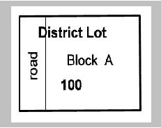 | |||
| Area of Road | = | X | ||||
| Area of Bk A | = | Y | ||||
|
|
||||||
| Total Area of DL 100 | = | Z (= X + Y) | ||||
| Note: District Lot 100 under survey | ||||||
| (ii) | SURVEY PLAN OF BLOCK A AND ROAD, DISTRICT LOT 100, CASSIAR DISTRICT | 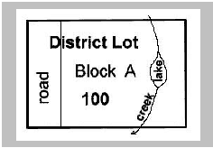 | ||||
| Area of Road | = | A | ||||
| Area of Bk A | = | B | ||||
| Area of Waterbody | = | C | ||||
|
|
||||||
| Total Area of DL 100 | = | Z (= A+B+C) | ||||
| Note: Waterbody is part of the district lot, but not part of Block A. District Lot 100 under survey. | ||||||
| (iii) | SURVEY PLAN OF DISTRICT LOT 100, YALE DIVISION OF YALE DISTRICT |  | ||||
| Area of Bk A (above) | ||||||
| Present Natural Boundary | = | X | ||||
| Area of Waterbody | = | Y | ||||
|
|
||||||
| Total Area of DL 100 | = | Z (= X + Y) | ||||
| Note: District Lot 100 under survey. | ||||||
| (iv) | SURVEY PLAN OF BLOCKS A to E AND ROAD, DISTRICT LOT 100, CASSIAR DISTRICT |
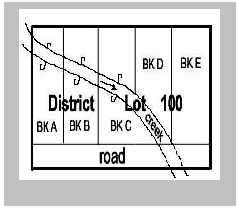 | ||||
| Area of Bk A | = | A | ||||
| Area of Bk B | = | B | ||||
| Area of Bk C | = | C | ||||
| Area of Bk D | = | D | ||||
| Area of Bk E | = | E | ||||
| Area of Road | = | F | ||||
| Area of Waterbody | = | G | ||||
|
|
||||||
| Total Area of DL 100 | = | H (= the sum of A to G) | ||||
| Note: Waterbody is part of the district lot, but not part of the blocks. District Lot 100 under survey. | ||||||
| (v) | SURVEY PLAN OF BLOCK A, DISTRICT LOT 100, YALE DIVISION OF YALE DISTRICT | 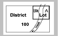 | ||||
| Area of Bk A (above present natural boundary) | = | X | ||||
| Note: An expression of the area for the creek running through Block A is not required. | In this example, District Lot 100 already exists. |
|||||
| (vi) | SURVEY PLAN OF DISTRICT LOT 200, AND BLOCK A OF DISTRICT LOTS 100 AND 200, YALE DIVISION OF YALE DISTRICT | 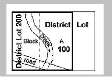 | ||||
| Area of Bk A (above PNB) in DL 100 | = | X | ||||
| Area of Road in DL 100 | = | Y | ||||
| Area of Bk A (above PNB) in DL 200 | = | A | ||||
| Area of Road in DL 200 | = | B | ||||
| Area of Waterbody in DL 200 | = | C | ||||
| Total Area of DL 200 | = | D (being A+B+C) | ||||
| Total Area of Bk A (above PNB) | = | E (being X+A) | ||||
| Note: PNB means present natural boundary | In this example, District Lot 100 exists. Block A and District Lot 200 are being created | |||||
| Note: Waterbody is part of district lots and not part of the block. | ||||||
42 Section 155 is amended
(a) in subsection (1) by striking out everything after "corners", and
(b) by adding the following subsection:
(4) Type 5 or better post must be set at the intersection of surveyed boundaries, except as outlined in section 156.
43 Section 156 is amended by repealing everything following paragraph (b) and substituting the following:
if the width of the right of way, easement or covenant is
(c) less than 6.5 m, no posts need be set at the intersections with the new parcel; however, the distance to the nearest corner along the property line must be shown, or
(d) 6.5 m or more, type 1, 2, 3, 4, or 5 posts must be set at the intersections with the new parcel.
44 Section 157 is repealed and replaced with the following:
157 If necessary, a surveyor may set posts on offsets from a corner.
45 Section 161 is amended by adding "plan" before "title".
46 Section 163 is amended by striking out ", other than posting plans or those creating only one parcel or an easement,".
47 Section 164 is amended
(a) by repealing paragraph (d),
(b) in paragraph (k), by adding "Road" after "Forest Service", and
(c) in paragraph (p), by adding "This plan was completed and checked, and the checklist filed under #............, on the.......... day of.........................., ........... and is hereby" before "Certified correct in accordance with Land Title Office records.".
48 Section 167 is amended by repealing the definition of ` "1 post claim", "2 post claim", "4 post claim", "fractional mineral claim" and "placer claim" ' and substituting the following definitions:
"1 post claim", "2 post claim", "4 post claim" and "fractional mineral claim" have the meanings given in the Mineral Tenure Act Regulation, B.C. Reg. 297/88;
"placer claim" has the meaning given in the Mineral Tenure Act; .
49 Section 168 is amended
(a) in subsection (3) by striking out ", district lot numbers and all pertinent survey information" and substituting "parcel designations", and
(b) by adding the following subsections:
(3.1) The material to be mined and the method of mining must be identified by the surveyor.
(4.1) If, during the survey process, the recorded holder of the mineral title wishes to amend the area of interest being surveyed, all prior title locations must be demonstrated and any abandonment, inclusion or reduction documents supplied.
50 Section 169 (1) is amended by striking out "subsection (2)" and substituting "subsections (2) and (3)".
51 Section 171 is amended by adding the following subsection:
(3) Surface coverages such as orchards, land under cultivation, buildings or dwellings must be accurately depicted on the plan.
52 Section 172 is amended
(a) in subsection (1) by striking out ", but merchantable trees may not be felled", and
(b) by adding the following subsection:
(4) If it is considered inappropriate to clear and blaze certain boundary lines, the surveyor must seek direction from the Surveyor General.
53 Section 178 is amended
(a) in subsection (1) (b) by striking out "practical" and substituting "practicable", and
(b) in subsection (3) (b) by striking out "18" and substituting "17".
54 Section 186 is repealed and the following substituted:
186 If bearing trees are not available, and if practicable, a cairn must be built to reference the position of all type 1, 2 or 4 posts.
55 Section 190 (1) is amended by adding ", to administrative areas not open to mining" after "were located", and by striking out "section 36" and substituting "sections 25, 35, 36, 37, 38 and 40".
56 Section 197 is amended by adding "(Land District)" before ", being", and, following "Placer Lease(s)", by striking out "District" and substituting "(Mining Division)".
57 Section 198 (j) is amended by striking out "claim surveys" and substituting "claim going to lease".
58 Section 208 (m) is amended by adding "Crown File No........................................" after "Well Authority No.........................................".
59 Section 210 (c) (ii) is amended by striking out "disposed" and substituting "dispensed".
Copyright © 2004: Queen's Printer, Victoria, British Columbia, Canada