| Copyright © Queen's Printer, Victoria, British Columbia, Canada |
Licence
Disclaimer |
||
|
|||
B.C. Reg. 536/2004, deposited December 3, 2004, pursuant to the PETROLEUM AND NATURAL GAS ACT [Section 133 (2)]. Order in Council 1163/2004, approved and ordered December 2, 2004.
On the recommendation of the undersigned, the Lieutenant Governor, by and with the advice and consent of the Executive Council, orders that, effective January 12, 2005, the Petroleum and Natural Gas Grid Regulation, B.C. Reg. 321/93, is repealed and the attached Petroleum and Natural Gas Grid Regulation is made.
— R. NEUFELD, Minister of Energy and Mines; S. BOND, Presiding Member of the Executive Council.
PETROLEUM AND NATURAL GAS GRID REGULATION
1 (1) In this regulation, "Act" means the Petroleum and Natural Gas Act.
(2) For the purposes of the Act and this regulation:
"block" means an area described in section 5;
"group" means an area illustrated in schedule 3;
"Peace River Block" means that area of land described in Schedule 1;
"quarter unit" means an area described in section 7;
"unit" means an area described in section 6.
2 The petroleum and natural gas grid is to be used to determine the location in British Columbia of petroleum and natural gas tenures under the Act, geothermal resource tenures under the Geothermal Resources Act and coal tenures under the Coal Act.
3 (1) The petroleum and natural gas grid is defined by a set of universal transverse mercator map projection coordinates for the northeast corner of each quarter unit illustrated in Schedule 3.
(2) The petroleum and natural gas grid must be issued and maintained by the Surveyor General, and is available for inspection at the office of the Surveyor General.
(3) The grid coordinates are the same as defined in the Mineral Tenure Online Grid Regulation.
(4) The petroleum and natural gas grid quarter unit coordinates are based on the North American Datum of 1983 Canadian Spatial Reference System (NAD83 CSRS).
(5) The petroleum and natural gas grid takes into account the historical petroleum and natural gas grid using the North American Datum of 1927 system of latitudes and longitudes.
(6) Despite subsection (1), the defining of the petroleum and natural gas grid using universal transverse mercator map projection coordinates does not affect existing rights.
4 For the purposes of section 58 (2) of the Act, the prescribed areas are set out in Schedule 2.
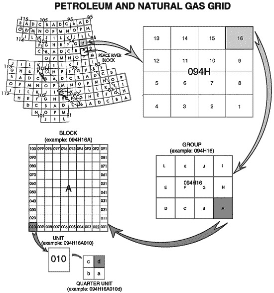
5 (1) A block is to consist of 100 units divided into 10 rows by 10 columns.
(2) The units are to be numbered from 1 to 100, starting in the southeast corner of the block, with the rows numbered consecutively as follows and as illustrated in Schedule 3:
(a) the first row numbered consecutively from 1 to 10 from right to left;
(b) the second row numbered consecutively from 11 to 20 from right to left;
(c) the third row numbered consecutively from 21 to 30 from right to left;
(d) the fourth row numbered consecutively from 31 to 40 from right to left;
(e) the fifth row numbered consecutively from 41 to 50 from right to left;
(f) the sixth row numbered consecutively from 51 to 60 from right to left;
(g) the seventh row numbered consecutively from 61 to 70 from right to left;
(h) the eighth row numbered consecutively from 71 to 80 from right to left;
(i) the ninth row numbered consecutively from 81 to 90 from right to left;
(j) the tenth row numbered consecutively from 91 to 100 from right to left.
(3) For the purposes of identification, blocks are to be named by combining their group name and block letter into a single string (for example, 094H16A).
(4) The legal boundaries and area of a block are to be determined by combining the areas of all the units within the block.
6 (1) A unit is to consist of four quarter units divided into 2 rows by 2 columns.
(2) The quarter units are to be identified by the letters a through d, starting in the southeast corner of the unit, with the first row lettered right to left a, b, and the second row lettered left to right c, d, as illustrated in Schedule 3.
(3) For the purposes of identification, units are to be named by combining their group name, block letter, and unit number into a single string (for example, 094H16A010).
(4) The legal boundaries and area of a unit are to be determined by combining the areas of all the quarter units within the unit.
7 (1) A quarter unit is an area defined by four straight lines joining the coordinates illustrated in Schedule 3 for its northeast corner and the coordinates of those quarter units which have their northeast corners common to the northwest, southwest, and southeast corners of the quarter unit.
(2) For the purposes of identification, quarter units are to be named by combining their group name, block letter, unit number and quarter unit letter into a single string (for example, 094H16A010d).
1 "Peace River Block" means that area of land in the Peace River Land District of British Columbia with corners having the following geographical values, all referenced to the (NAD83 CSRS):
Northeast corner, latitude 56º40'57.77", longitude 120º00'04.64";
Southeast corner, latitude 55º38'08.88", longitude 120º00'04.86";
Southwest corner, latitude 55º37'15.50", longitude 121º56'07.71";
Northwest corner, latitude 56º40'01.35", longitude 121º59'18.46".
1 AREA 1
All of Vancouver Island
2 AREA 2
Those units contained within the following described Blocks and Groups:
Blocks I, J and K of Group 931/16;
Blocks A to C (inclusive) and F to K (inclusive) of Group
93P/1,
Blocks A to C (inclusive) and F to L (inclusive) of Group 93P/7,
Groups 93P/8 to 16 (inclusive);
Groups 94A/1 to 8 (inclusive),
Blocks A to E (inclusive) and L of Group 94A/9,
Groups 94A/10 to 15 (inclusive),
Blocks D, E and L of Group 94A/16;
Blocks A, B and G to J (inclusive) of Group 94B/9,
Group 94B/16;
Blocks A to H (inclusive) of Group 94G/1,
Blocks A, B, G and H of Group 94G/2;
Blocks D and E of Group 94H/3,
Blocks A to H (inclusive) of Group 94H/4.
3 AREA 3
Those units contained within the following described Blocks and Groups:
Groups 92G/1 and 2,
Blocks A, B and G to K (inclusive) of Group 92G/3,
Blocks G to L (inclusive) of Group 92G/5,
Groups 92G/6 to 8 (inclusive),
Groups 92H/4 and 5 (inclusive of those lands within the Province of British Columbia).
Copyright © 2004: Queen's Printer, Victoria, British Columbia, Canada